More New LRT Systems Sprouting Across North America


Ottawa Confederation LRT (left), Oklahoma City Streetcar (right). Photo: YouTube screenshots by LRN.

It’s no secret that the Covid pandemic cast a pall upon public transport, and light rail transit (LRT) has certainly been no exception. But the good news, particularly in North America, is that, while ridership has taken a hit, major construction and enhancements have proceeded for many existing LRT operations. 

Moreover, in recent years, even through the pandemic, totally new-start LRT projects for several North American cities (including in some metro areas already operating other forms of urban rail) have also been making progress. Light Rail Now reported briefly on several of these systems as they were under construction eight years ago. 

At that time, the major new North American light rail system to open had been Norfolk’s <em>The Tide</em> rapid-type LRT in 2011. Now, since then, a swath of additional new systems have opened in the United States and Canada, and more projects are heading toward startup. Tabulated below is a quick rundown of these most recent new-start LRT projects, both “rapid” light rail and streetcar.

In this brief summary, all new rolling stock in the new streetcar lines described is modern except for heritage PCC cars in El Paso. In most cases, power to rolling stock is supplied by an overhead contact system (OCS, typically simple trolley wire or catenary), but some installations include battery operation as noted. Power is supplied at 750 VDC unless indicated otherwise.


LRT new starts: USA

► Salt Lake City: S-Line streetcar • Opened 2013 ► Using a former railway branch alignment, this 2.0-mi/3.2-km route connects the city’s Sugar House district with the nearby suburban community of South Salt Lake and links up with the region’s Trax rapid-type LRT system.

► Tucson: Sun Link streetcar • Opened 2014 ► Currently operating over a 3.9- mi/6.3-km route and powered by a standard OCS installation, the city’s streetcar-based urban rail system connects the University of Arizona campus with downtown Tucson and the Mercado District under development to the west.

► Atlanta: Atlanta streetcar • Opened 2014 ► This 2.7-mi/4.3-km line currently provides connections and pedestrian circulation services in a loop connecting Centennial Olympic Park with the Martin Luther King, Jr. National Historical Park and nearby neighborhoods east of downtown, including a direct link to the MARTA rapid transit system’s Peachtree Center station and other transit lines.

► Dallas: Dallas streetcar • Opened 2015 ► This 2.4-mi/3.9-km line modern streetcar line connects downtown Dallas to Oak Cliff, across the wide Trinity River flood plain, by way of the Houston Street Viaduct. An extension to the Bishop Arts District opened in 2016. Cars are mainly powered by OCS, but run on battery power over the viaduct. The modern system is totally separate from, and unconnected to, the heritage McKinney Avenue Streetcar line that has served its important neighborhood and commercial district since 1989.

► Charlotte: CityLynx streetcar • Opened 2015 ► Designated the Gold Line within Charlotte’s urban rail system, this 4.0-mi/6.4-km modern streetcar line initially opened over a mainly east-west route following Beatties Ford Road, Trade Street, and Central Avenue through central Charlotte. Additional links from the Charlotte Transportation Center to French Street, and from Hawthorne & 5th to Sunnyside Avenue opened for service in 2021.

► Washington: DC Streetcar • Opened 2016 ► Currently streetcar service operates over a 2.4-mi/3.9-km segment running in mixed traffic along H Street and Benning Road in the city’s Northeast quadrant.

► Kansas City: KC Streetcar • Opened 2016 ► Kansas City’s streetcar-based urban rail system follows a 2.2-mile/3.5 km route between the River Market and Union Station, mostly along Main Street, running through the city’s central business district and the Crossroads Arts District.

► Cincinnati: Cincinnati Bell Connector streetcar • Opened 2016 ► The service operates in mixed traffic on a 3.6-mi/5.8-km loop from The Banks, Great American Ball Park, and Smale Riverfront Park through downtown Cincinnati and north to Findlay Market at the northern edge of the historic Over-the-Rhine neighborhood.

► Detroit: QLine streetcar • Opened 2017 ► Originally called the M-1 Line by its developers, this 3.3-mi/5.3-km streetcar service connects Downtown Detroit with Midtown and New Center, running along Woodward Avenue for its entire route. Lithium batteries provide power in about 60% of the operating cycle, with OCS powering cars and recharging in the remainder.

► Milwaukee: The Hop streetcar • Opened 2018 ► Milwaukee’s Streetcar, branded as The Hop, provides a modern streetcar service over an initial 2.1 mi/3.4 km route connecting the Milwaukee Intermodal Station and Downtown to the city’s Lower East Side and historic Third Ward neighborhoods. A 0.4-mile/640-m Lakefront branch to the proposed “Couture” high-rise development has been mostly constructed, and is expected to open imminently. Power is supplied by OCS, mostly simple trolley wire, except for 3,300 feet (1 kilometer) in sections along Kilbourn Avenue and Jackson Street where cars are powered only by their batteries.

Passengers deboarding Milwaukee’s The Hop streetcar. Photo: The Hop.

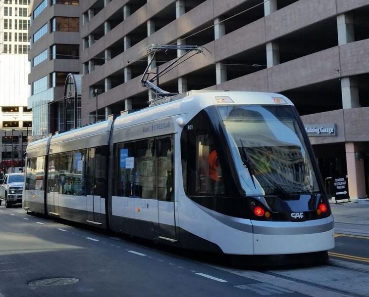
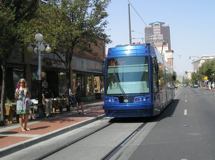
► Oklahoma City: OKC Streetcar • Opened 2018 ► This 4.8 mi/7.7 km system is routed over two lines that connect Oklahoma City’s Central Business District with the entertainment district, Bricktown, and the Midtown District. Most operation is powered under OCS except for two short segments where cars operate under battery power. (See photo at beginning of article.)

► El Paso: El Paso Streetcar (heritage) • Opened 2018 ►Using a fleet of renovated historic streetcars, this line runs 4.8 mi/7.7 km over two loops from through El Paso’s uptown and downtown areas to the University of Texas at El Paso. Notably, the historic PCC cars refurbished for the project had been kept in storage since the city’s last original streetcar operation was abandoned in 1974.

► Phoenix: Tempe Streetcar • Opened 2022 ► Serving Tempe, a large suburban city adjacent to Phoenix’s east side, this 3.4-mi/5.7-km modern streetcar line running in streets with mixed traffic connects the Arizona State University campus with downtown Tempe and neighborhoods to the south. It intersects several stations of the city’s rapid Valley Metro LRT system. Power for the streetcars varies between OCS and onboard batteries.

► Orange County, California: OC Streetcar • Opening planned 2023 ► This 4.2 mi/6.7 km modern streetcar (LRT) line is currently under construction in Orange County, California, running through the cities of Santa Ana and Garden Grove, routed partly in mixed traffic and in dedicated right-of-way. New infrastructure includes constructing a new double-track rail bridge and an overpass over a busy arterial.

► Washington DC (Maryland suburbs): Purple Line LRT • Opening planned 2026 ► This 16.2-mile (26.1 km) rapid LRT line is intended to link several Maryland suburbs of Washington, D.C.: Bethesda, Silver Spring, College Park, and New Carrollton. The line will also enable riders to transfer between the Maryland branches of the Red, Green, Yellow, and Orange lines of the Washington Metro without riding into central Washington, and between all three lines of the MARC regional (commuter) rail system. Power, likely to be delivered by OCS in a catenary suspension, will be energized at 1,500 volts (placing the Purple Line in a small category of new higher-power North American LRT systems that also includes Seattle’s Link and Ottawa’s Confederation Line).

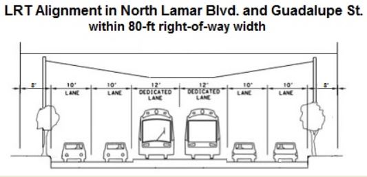
► Austin: MetroRail LRT • Opening planned 2029 ► Public transit agency Project Connect is planning two light rail lines, designed to operate free from traffic to link key destinations throughout Austin. The Orange Line, serving Austin’s crucial central north-south local travel corridor, is planned to stretch approximately 21 miles (34 km) to link North and South Austin. From Tech Ridge in the north, the line would follow North Lamar Blvd. and Guadalupe St., connecting the University of Texas campus, dense West Campus neighborhood, the Capitol Complex (state government offices), and downtown before crossing the Colorado River and heading south along South Congress Ave. to Slaughter Ln. in the far south of the city. The Blue Line would provide service over a 15-mile (24-km) route starting at U.S. 183 in North Austin, sharing the Orange Line alignment into downtown, then crossing the river and proceeding southeast to Austin-Bergstrom International Airport. Included in the original plan is 1.6-miles (2.6 km) of LRT tunnel as alignments through downtown for both Orange and Blue lines as well as a future eastside Gold LRT line.


LRT new starts: Canada

► Waterloo Region (Ontario): ION Light Rail • Opened 2019 ► The Waterloo Region is a cluster of urban villages about 55 miles southwest of Toronto. The 11.8-mi/19.0 km first stage of the planned larger ION LRT system, basically an interurban LRT service, connects Conestoga Station in Waterloo to Fairway Station in Kitchener, including 19 stations, some of them designed to serve trains in each direction on a single track. A particularly interesting technical feature is track-sharing with heavy freight railroads and the used of interlaced (“gauntlet”) track to facilitate operation through switches and clearances at stations.

Waterloo-Kitchener ION LRT train entering station in private right-of-way alignment, June 2019. Photo: Jason, Wikipedia.

► Ottawa: Confederation Line LRT • Opened 2019 ► The Confederation Line (Line 1) represents Ottawa’s first deployment of actual LRT technology, and replaces a section of the Bus Rapid Transit (BRT) Transitway that previously served the city center. (See photo at beginning of article.) This new line, completely grade-separated, runs both underground and on the surface 7.8 mi/12.5 km east–west from Blair to Tunney’s Pasture, connecting to the Transitway at each end and with the Trillium rail service at Bayview. It includes a tunnel through downtown with three subway stations. Electrification is relatively high at 1,500 VDC, delivered to trains by catenary-type OCS (similar to the power system used by Seattle’s Link LRT). It must be noted that the diesel-powered Trillium line, described locally as “light rail”, is technologically equivalent to other light-capacity regional diesel-multiple-unit (DMU) services (lately called “hybrid rail” by the U.S. Federal Transit Administration) such as those in New Jersey (River Line), Southern California (Sprinter), and Austin (MetroRail Red Line).

► Peel Region (Ontario): Hurontario LRT • Opening planned 2024 ► The Peel Region is a regional municipality of the Greater Toronto Area, just to the west and northwest of the city of Toronto, encompassing the suburban cities of Mississauga and Brampton, among other smaller communities. The Hurontario LRT, currently under construction, is a 10.9 mi/17.6-km light rail line planned to run on the surface along Hurontario Street from the Port Credit GO Station in Mississauga to Steeles Avenue in Brampton.

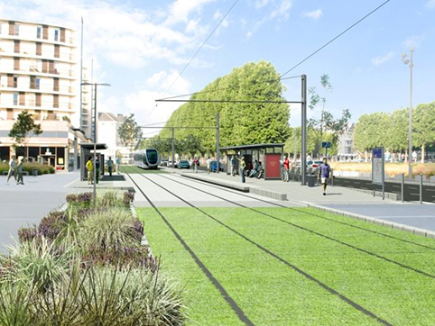
► Quebec City: Quebec City Tramway • Opening planned 2026 ► This light rail transit line in Quebec City is planned to open in 2026. The initial 14-mi/23-km route will link Charlesbourg to Cap Rouge, passing through Quebec Parliament Hill. While the line will include a 2.2-mi/3.5-km underground segment, most of it will be constructed on the surface.   

► Hamilton: Hamilton LRT  • Opening date TBD ► Hamilton is a large industrial and port city about  28 miles/45 kilometers southwest of Toronto in the Greater Toronto and Hamilton Area.  The Hamilton LRT (also known as the B-Line) is planned to operate along Main Street, King Street, and Queenston Road, extending 8.7 miles (14 kilometers), with 17 station-stops, from McMaster University to Eastgate Square via downtown Hamilton.

It should be noted that a 26-km (16-mi) starter line for a major LRT system has also been proposed for the city of Gatineau, Quebec, located on the northern bank of the Ottawa River, immediately across from Ottawa, Ontario within Canada’s National Capital Region. However, funding has not yet been finalized.


Considerations for other cities

This vigorous bustle of totally new light rail starts in nearly two dozen cities across North America is breathtaking – 21 new LRT installation projects (both rapid LRT and streetcar) in eight years. That’s not counting all the new extension projects of existing systems in cities like Seattle, Minneapolis, Milwaukee, Charlotte, Los Angeles, Phoenix, Edmonton, Calgary, and more.

The explosive growth of new LRT starts suggests that community members and civic leaders across the continent are increasingly recognizing the unique advantages of LRT for their cities – its exceptional attractiveness as public transport, and its powerful ability to catalyze and attract adjacent real estate development. This has simultaneously improved urban mobility, improved environmental quality, helped guide land use with techniques such as transit-oriented development (TOD), and boosted local taxbase with significant returns on investment (ROI).

Across North America, cities of various sizes remain that have no urban rail. San Antonio, Las Vegas, Indianapolis, Louisville, Omaha, Des Moines, Boise, Spokane, Knoxville, Raleigh, Richmond, Providence, Victoria, and Winnipeg are just a handful of the dozens of communities that would likely benefit from considering some form and application of light rail. The new starts that this article has summarized certainly provide some models to examine. ■

Simulation of Quebec City Tramway in street alignment. Graphic:  YouTube screenshot by LRN.


Reference sources

Light rail in the United States, Wikipedia, updated 7 November 2022.

https://en.wikipedia.org/wiki/Light_rail_in_the_United_States

List of North American light rail systems by ridership, Wikipedia, 22 November 2022.

https://en.wikipedia.org/wiki/List_of_North_American_light_rail_systems_by_ridership

Urban rail transit in Canada, Wikipedia, updated 11 November 2022.

https://en.wikipedia.org/wiki/Urban_rail_transit_in_Canada

Dallas Streetcar, Wikipedia, updated 7 October 2022.

https://en.wikipedia.org/wiki/Dallas_Streetcar

CityLYNX Gold Line Streetcar, City of Charlotte website, accessed 29 November 2022.

https://charlottenc.gov/cats/rail/cityLYNX/Pages/default.aspx

CityLynx Gold Line, Wikipedia, updated 29 October 2022.

https://en.wikipedia.org/wiki/CityLynx_Gold_Line

DC Streetcar, Wikipedia, updated 24 October 2022.

https://en.wikipedia.org/wiki/DC_Streetcar

Editorial, A new streetcar in Arizona: Tempe! Urban Transport Magazine webpage, 20 May 2022.

https://www.urban-transport-magazine.com/en/a-new-streetcar-in-arizona-tempe/

Tempe Streetcar, Wikipedia, updated 27 October 2022.

https://en.wikipedia.org/wiki/Tempe_Streetcar

Tempe Streetcar, Valley Metro website, accessed 2022-11-28.

https://www.valleymetro.org/project/tempe-streetcar

Tempe Streetcar, Stacy and Witbeck website, accessed 2022-11-28.

https://www.stacywitbeck.com/projects/tempe-streetcar/

El Paso Streetcar, Wikipedia, updated 19 August 2022.

https://en.wikipedia.org/wiki/El_Paso_Streetcar

The Hop (streetcar), Wikipedia, updated 25 November 2022.

https://en.wikipedia.org/wiki/The_Hop_(streetcar)

KC Streetcar, Wikipedia, updated 26 November 2022.

https://en.wikipedia.org/wiki/KC_Streetcar

QLine, Wikipedia, updated 28 November 2022.

https://en.wikipedia.org/wiki/QLine

About the Oklahoma City Streetcar, Oklahoma City Streetcar website, accessed 30 November 2022

Oklahoma City Streetcar, Wikipedia, updated 19 August 2022

https://en.wikipedia.org/wiki/Oklahoma_City_Streetcar

OC Streetcar, Wikipedia, updated 2 November 2022.

https://en.wikipedia.org/wiki/OC_Streetcar

Light Rail Overview, Purple Line website, Maryland Transit Commission, accessed 29 November 2022.

https://www.purplelinemd.com/about-the-project/overview

Purple Line (Maryland), Wikipedia, updated 29 November 2022.

https://en.wikipedia.org/wiki/Purple_Line_(Maryland)

Project Connect Transit Plan, HDR website, accessed 29 November 2022.

https://www.hdrinc.com/portfolio/project-connect-transit-plan

Project Connect, Wikipedia,  updated 4 September 2022.

https://en.wikipedia.org/wiki/Project_Connect

Stage 2 ION light-rail project receives provincial clearance, Mass Transit online, June 22, 2021

https://www.masstransitmag.com/rail/article/21227649/stage-2-ion-lightrail-project-receives-provincial-clearance

Confederation Line, Wikipedia, 27 November 2022.

https://en.wikipedia.org/wiki/Confederation_Line

Quebec City Tramway, Wikipedia, updated 3 October 2022.

https://en.wikipedia.org/wiki/Quebec_City_Tramway

Quebec City tramway finally gets green light as province gives unconditional approval, CBC News, 6 April 2022.

https://www.cbc.ca/news/canada/montreal/tramway-quebec-city-approved-1.6410943

Regional Municipality of Peel, Wikipedia, 30 September 2022.

https://en.wikipedia.org/wiki/Regional_Municipality_of_Peel

Desmond Brown, Procurement process for LRT to start later this year, construction in 2024, [Hamilton] CBC News, 18 July 2022.

https://www.cbc.ca/news/canada/hamilton/hamilton-lrt-project-1.6524030

Hamilton LRT, Wikipedia, updated  28 September 2022.

https://en.wikipedia.org/wiki/Hamilton_LRT

In memoriam Dave Dobbs

David “Dave” Duncan Dobbs
6 March 1939 – 12 July 2021
Dave riding a Dallas light rail transit train, June 2012.

With deep sorrow and profound grief we report the loss of our dear friend and colleague Dave Dobbs, who died suddenly and unexpectedly in his home in Austin, Texas on 12 July 2021. Dave was Executive Director of the Texas Association for Public Transportation (TAPT) and publisher of the LightRailNow.org website.

An online memorial, including Dave’s obituary, can be accessed at:
https://www.dignitymemorial.com/obituaries/austin-tx/david-dobbs-10269173

A memorial service, organized by his daughters Kyleen and Wendy, his adopted daughter Trish, and his granddaughter Tiffany, was held on 31 July 2021.

The following remarks were delivered by Dave’s close friend and professional colleague Lyndon Henry, a board member of TAPT and contributing editor for Light Rail Now.


I first met Dave in 1979 when he came to the small business I owned to have a paper edited and typed. I was also running a nonprofit, Texas Association for Public Transportation, or TAPT, out of the same office. Dave was curious, so I explained that since 1971, I had presented feasibility studies that had persuaded local officials to include rail transit in official planning.

This issue immediately engaged Dave’s interest. Thus began a friendship and professional relationship that would last for the next 42 years.

From that epiphany Dave devoted a vast amount of his time, energy, passion, and intellect to light rail and public transportation. Ultimately Dave would play a significant role in altering the direction of transportation policy and shaping part of the world we live in today.

We found we would each learn from the other. As we’d bat issues and ideas back and forth like a volleyball, they’d grow and evolve into deeper concepts, plans, and strategies.

In the 1980s and 1990s, Dave worked closely with me to achieve several key successes:

Our recommendations for a mass transit authority with a full 1% sales tax – enough to fund a light rail system – were adopted by the Austin City Council, and Capital Metro exists today fully funded largely because of what Dave and I did at that time.

We worked together in the successful campaign to create Capital Metro. We then participated in a planning process that recommended a central light rail line as the Locally Preferred Alternative for Austin, a recommendation adopted by the Capital Metro board. This put light rail firmly on Austin’s agenda.

In 1989, when I was appointed to the Capital Metro Board, Dave became Executive Director of TAPT, which has supported our educational work. In the late 1990s, Dave spearheaded an effort to run a diesel-powered railcar on the railway line owned by Capital Metro. This successful demonstration project inspired the community’s imagination. Voters approved funding for a rail transit line in 2004, and today Dave’s concept is in operation as Capital Metro’s MetroRail Red Line that has been running between downtown Austin and Leander since 2010.

I should mention that Dave was also involved in promoting Amtrak’s rail passenger service. In 2000 he proudly rode a special Amtrak train reinstating the Texas Eagle and inaugurating daily service.

It was in the early 2000s that Dave started taking both of us on trips around the country to attend various meetings and present papers at major transit conferences. Altogether, we made about three dozen trips over 19 years.

I think Dave might have missed his calling as an evangelist. He loved to proselytize, and his gospel was public transportation and the benefits of rail transit, rail passenger service, and better urban planning. Time and again I’d be waiting for Dave, only to find him spending 15 or 20 minutes lecturing to a hotel desk clerk, receptionist, busboy, or some other random person about the value of light rail or transit-oriented development.

A couple of our trips included some particularly unforgettable experiences. In 2003, after a conference, we decided to climb Atlanta’s famous Stone Mountain. Halfway up we stopped to admire the vista with some picturesque grey clouds in the distance. When we reached the summit, it was getting dark, but even worse, those picturesque grey clouds had drifted right on top of us, and it was starting to thunder and drizzle. Then lightning started to flash with terrifying explosions.

We got caught in probably the most dangerous thunderstorm either of us had ever experienced. Blinded by the darkness and torrential rain, we got separated as we tried to descend the slippery mountain, and Dave was trying to help a couple with a baby. It looked like we’d either be swept away by the deluge or barbequed by the crashing bolts of lightning. Fortunately, we survived to tell the tale.

Another time was after an event in 2004. We wanted to take photos of St. Louis’s Metrorail light rail line in the Illinois suburbs, so we rode a train to a suburban station. Some security guards on the platform gave us permission to take photos and kindly offered some tips about where to get the best views of trains.

Returning to the light rail station about half an hour later, we were met by an Illinois Sheriff’s Deputy. It turned out that the same “helpful” security guards had reported us as “suspicious”. We were detained for about 45 minutes, grilled, admonished, and uncertain of our fate. We got off with a stern warning not to take photos of light rail trains. After all, 9/11 was only three years in the past.

Fortunately, most of the time we managed to stay out of trouble. And by facilitating these trips and activities, Dave enabled us to make an impact in furthering light rail development across the country.

Dave’s crowning achievement was to devise and promote a central light rail route for Austin, running down North Lamar, Guadalupe, and South Congress, parallel to I-35. Since 2016, Dave publicized this everywhere, handing out a map and speaking to key public officials

That route grabbed the public’s imagination. It was incorporated into official plans, and last November, voters approved billions of dollars to fund it. Dave’s concept is the exact light rail route now being implemented as the Orange Line.

Capital Metro, MetroRail, Project Connect’s Orange Line — Dave Dobbs has had an amazingly momentous influence on the shape and urban environment of the Austin area, today and into the future. Let that never be forgotten. ■


Dave in 2003. He was an avid cyclist as well as vigorous proponent of public transportation.

Average unit cost of installing light rail in street/arterial alignments

Left: Phoenix LRT in arterial alignment. Right: Houston LRT in street alignment. Photos: L. Henry.

Left: Phoenix LRT in arterial alignment. Right: Houston LRT in street alignment. Photos: L. Henry.

Increasingly, interest has been growing in the use of street and arterial roadway rights-of-way (ROW) as alignments for new light rail transit (LRT) segments – either new-start systems or extensions to existing systems. As planners, other professionals, advocates, and civic leaders consider such projects, it’s useful to have reliable data on the installation costs.

Unfortunately, many available “average unit cost” methodologies present averages based on various types of alignment — such as re-purposed railroad ROW – rather than exclusively or predominantly street/arterial corridors, which present quite specific needs, challenges, and costs with respect to installation of LRT. For example, while railroad ROWs typically need rehabilitation, much of the necessary preparation for LRT tracklaying is usually in place; space and installations costs for overhead contact system (OCS) infrastructure and stations are often easier to deal with. On the other hand, installing LRT tracks, stations, and electrical systems in streets/arterials typically requires extra (and more costly) tasks such as pavement removal, subsurface utilities relocation, traffic management and reconfiguration, and other measures.

The brief study described in this post has been undertaken as an effort toward fulfilling the need for reliable total-system unit cost data for street/arterial LRT project installations. It has focused on predominantly (or exclusively) street/arterial LRT projects, drawing upon data from eight specific projects in five U.S. cities (Salt Lake City, Houston, Portland, Phoenix, and Minneapolis) as listed in the table further below.

Also, this study (conducted by LRN technical consultant Lyndon Henry) has endeavored to avoid carelessness as to what is designated as “light rail”. As it has been most pervasively considered since the 1970s, LRT is regarded to be an electrically powered mode, not a light diesel-powered regional railway. For the purposes of this study, LRT has been considered as both electrically powered and operating predominantly in exclusive or reserved alignments (i.e., streetcar-type systems have been excluded).

Analysis of this data has yielded an average capital cost of $85.5 million per mile ($53.0 million per kilometer) for construction in these kinds of alignments. This figure might be considered appropriate for approximating system-level planning cost estimates for corridors considered possible candidates for LRT new starts or extensions. (Capital costs, of course, may vary significantly from corridor to corridor depending on specific conditions, infrastructure needs, service targets, and other factors.)

It should be noted that these data have been primarily drawn from Federal Transit Administration resources (particularly New Start profile reports), supplemented where necessary by data from Light Rail Now and Wikipedia. Because these figures present final total capital cost data, they represent final year-of-expenditure costs, including infrastructure and vehicle requirements, and incorporate other typical ancillary cost items such as administration, engineering, contingencies, etc.

Capital costs for the eight projects were tabulated as shown in the table below.


Relevant data for 8 LRT segments used in study. (Click to enlarge.)

Relevant data for 8 LRT segments used in study. (Click to enlarge.)


NOTES

Portland: Interstate (Yellow) line data include section at outer (northern) end on viaduct over Columbia Slough and flood plain. Phoenix: Initial project data include new LRT bridge over Salt River, and short section on abandoned Creamery Branch of Southern Pacific Railroad. Minneapolis: Green line data include adaptation of roadway bridge over Mississippi River.

It should also be recognized that the design requirements and installation costs of streetcar-type LRT projects average significantly lower than those of rapid or interurban-type LRT, particularly because of several factors. For example, streetcar alignments predominantly share street/arterial lanes with existing motor vehicle traffic. Stations often consist of simple “bulge-outs” from adjacent sidewalks, and are typically designed for single-car trains (i.e., single vehicles) rather than multi-car LRT trains. Also, the lighter static and dynamic loading requirements of some streetcar configurations facilitate the use of lower-cost “shallow slab” construction rather than the deeper excavation more typical of “heavier” LRT designs.

Capital costs and line lengths were aggregated for all eight LRT cases studied. Results are presented in the table below:


Data and calculation of average LRT project cost in street/arterial alignments.

Data and calculation of average LRT project cost in street/arterial alignments.


Hopefully, the information from this study will be helpful in developing realistic cost estimates for new LRT projects in these types of alignments. ■

Welcome NARP’s intern to Texas June 10-13 on her 10,000-mile rail/bike journey

Elena Studier. Photo courtesy Texas Rail Advocates.

Elena Studier. Photo courtesy Texas Rail Advocates.

by Peter LeCody

The following article by Peter LeCody of Texas Rail Advocates and the National Association of Rail Passengers (NARP) is posted here at Peter’s request.

It’s not unusual that a 20-year-old college student would want to see the country over her summer break. What is out of the norm is that this young lady is doing it by rail. 10,000 miles. With her bike. The ideal summer road, make that rail, trip.

National Association of Railroad Passengers Intern Elena Studier is more than halfway through her 38-day jaunt around the country with her bike named “Stevie” and will be coming through Texas starting Friday, June 10. She’s showing how it’s easy to find her way around the country utilizing Amtrak, local and urban rail and bus systems, and most of all, enjoying bike rides and meeting people all along the way. Her website is www.summerbyrail.com and she’s also on twitter @railpassengers.

BikeTexas will host Elena on her stops in San Antonio, Austin, Fort Worth and Dallas with bike rides.

Here’s where you can see Elena and give her a big Texas welcome and, if you have a bike, come join in a ride.

San Antonio — It starts at the Alamo in San Antonio at 8am Friday, June 10. A 12-mile easy-pace bicycle ride on the Mission Trail (leave from the Alamo and ride to Mission Espada)

Austin — Friday afternoon, June 10. Local VIPs and media welcome Elena at the Amtrak station and lead a 10-mile easy-pace bicycle ride (loop) including the Butler Trail around Town Lake. Following bike ride, Elena and group on bicycles take the Capital Metro Red Line (TBD) from Plaza Saltillo to Black Star Co-op Pub and Brewery

Fort Worth — Saturday, June 11. Elena arrives at the Fort Worth Intermodal Transportation Center aboard the Northbound Amtrak Texas Eagle trains #22 and takes a tour of the station. Local VIPs and media welcome Elena and lead a less-than-10-mile easy-pace loop bicycle ride. Before the 5:25 PM departure of the northbound Heartland Flyer to Oklahoma City Elena will inspect the new bike carrier car on the train.

Dallas — Sunday, June 12. Elena starts the day at 9:00 am at Dallas Union Station with a BikeTexas ride on the Katy Trail that takes her to Mockingbird Station. There she will take the DART Rail Blue line to the White Rock Station for a leisurely bike ride around White Rock Lake, capping off the day’s activities. Monday, before departing on Amtrak for San Antonio, she will meet with executives of Texas Central Railway, the private company building a highspeed rail line between Dallas and Houston, to learn how they will accommodate bikes on their trains. ■


The following media release from NARP provides additional background on Elena’s around-the-country rail and bike journey …

NARP Sends Intern on the Ultimate Summer “Road Trip”

#SummerByRail to Stop at 20 Cities in 38 Days, Covering 10k Miles by Rail and Bike

Washington, D.C. — With school and finals behind her, college sophomore Elena Studier this summer is taking her bike on an epic 38-day multi-modal “road trip” across the country by rail, visiting more than 18 cities and 15 states. Studier, 20, spent her school year interning with NARP and sketching out her big adventure. She kicks off her trip in New York City and will make stops in 20 locations—including Glacier National Park in Montana–before concluding more than 10,000 miles later in Washington, D.C. on June 20, 2016.

Ms. Studier will chronicle her trip on her blog, “Summer by Rail,” to highlight the 21st Century’s public transportation services in America, and capture how people live and move in different regions of the U.S.

“‘Summer by Rail’ is my effort to share with people the ever-changing lifestyles that we have in this country, and show the relationship people have with transportation services like rail, subways, buses, and bikes,” said Ms. Studier, who originally proposed the idea as her summer internship for NARP. “Millions of people in the U.S. think that public transportation is only for major metropolitan areas, but these services can connect people from coast to coast, to the sights and attractions of cities, and to national parks like the Grand Canyon.”

During the trip, Studier’s main modes of transportation will be passenger rail with Amtrak, and her bicycle, which she has dubbed “Stevie.” As Elena and Stevie travel from city to city, she will use other forms of public transportation to highlight the rich assortment of modes available to travelers including buses, ferries, trollies, ride-sharing, and more.

“Elena’s trip is a new and major project for NARP, as we want to highlight that people – friends and families – can travel across the country by passenger rail, and other services easily, seamlessly and comfortably,” said Jim Mathews, President and CEO of NARP. “People often talk about commuting by rail in Europe or Asia, and think they can’t do it in the U.S., but that’s not true. Elena’s trip will connect her to some of the biggest cities and attractions in the country.”

Studier’s “Summer by Rail” project will begin on May 15th, with the first leg of her route taking her to Chicago, IL. Studier will visit 20 cities and multiple attractions on her trip including Seattle, WA; Portland, OR; St. Paul, MN; Denver, CO; Los Angeles, CA; Grand Canyon, AZ; New Orleans, LA and many more. Studier’s last leg will see her travel from Raleigh, NC to Washington, D.C on June 20th.

People can follow Studier’s “Summer by Rail” trip at www.SummerbyRail.com, where she will blog about her experience. Studier will also be running several social media accounts so people can follow her day-to-day activities. Social media channels and hashtags include:

• Instagram and Twitter: @RailPassengers
○ #SummerByRail
○ #ElenaAndStevie
○ #BikesonBoard
• Facebook.com/narprail
• YouTube.com/narprail


About the National Association of Railroad Passengers

NARP is the only national organization speaking for the nearly 40 million users of passenger trains and rail transit. We have worked since 1967 to expand the quality and quantity of passenger rail in the U.S. Our mission is to work towards a modern, customer-focused national passenger train network that provides a travel choice Americans want. Our work is supported by more than 28,000 individual members nationwide.

Caen: Guided BRT out, real LRT tramway in by 2019

Rendition of Caen's proposed LRT tramway that will replace problematic guided-BRT system. Graphic: Caen municipality.

Rendition of Caen’s proposed LRT tramway that will replace problematic guided-BRT system. Graphic: Caen municipality.

When the “tram on tyres” or “rubber-tired tramway” technology first emerged in the early 2000s, it was positioned as part of the new Bus Rapid Transit (BRT) concept attracting interest at the time. The argument went that “BRT” was “just like light rail, but cheaper”, and the “rubber-tired tramway” was intended to demonstrate that a “tram” constructed with automotive/bus technology could be “guided” just as a light rail transit (LRT) tramway was guided by its track rails, and able to operate extra-long, multi-articulated buses smoothly and reliably just like the tramcars on LRT railways.

A number of cities have experimented with or adopted the technology, particularly in France, where cities like Nancy, Clermont-Ferrand, and Caen made the “tram on tyres” the centerpiece of their transit systems. Now, plagued by reliability and performance problems, Caen is clearly fed up with it, and has launched a project to convert to a standard LRT tramway — running on bona fide tracks — by 2019.

In France, the designation TVR, Transport sur Voie Réservée, roughly translated as “transport on reserved way”, is used to refer to these rubber-tired guided-bus systems. In English, they’re often referred to as GLT, for Guided Light Transport. As explained in a Wikipedia article, “GLT vehicles bear a strong resemblance to trams, but are actually buses capable of following a single guidance rail or even operating without any surface guidance system.”

Opened in 2002, Caen’s guided-bus system eventually stretched to 15.7 km (9.8 miles), using longer-than-usual articulated buses guided by a flanged wheel running on a center guiderail in the middle of the paveway. While the buses have diesel motors (and steering wheels, so they can be driven to their garage at night), their ordinary propulsion is electric power, via an overhead contact system (OCS) and LRT-like pantographs, with the guiderail also serving as the electrical return circuit. (The dual rails of standard LRT serve this same purpose.)

Caen guided BRT ("rubber-tired tramway") system, now scheduled for replacement by LRT. Photo: TendanceOuestRouen.com.

Caen guided BRT (“rubber-tired tramway”) system, now scheduled for replacement by LRT. Photo: TendanceOuestRouen.com.

However, reliability problems with the technology (especially derailments of the guidewheels) reportedly have persuaded Caen’s political leadership and transit management to ditch the guided-bus system. In the new LRT tramway plan (see graphic simulation at top of post), 16.8 km (10.4 miles) of LRT routes will replace (and slightly extend) the guided-bus routes, and tracks will replace the paveways (or be embedded in some sections of pavement). A fleet of 23 trams is projected to replace the BRT buses, with a total project cost estimated at €247 million (currently about $269 million, or about $26 million per mile). Project completion is aimed for 2019.

From its early years, the usefulness of the system, as a substitute for standard LRT, baffled transit advocates and professionals. As John Carlson, one advocate posting to the Eurotrams list in 2004, commented

I found the system at Caen and also the one at Nancy to be a solution in search of [a] problem. While there must be some economies from installing just a guide rail instead of double-railed load bearing track looking at the system in [situ] I would have to ask if the guide rail is needed at all.

The vehicles are long and do turn some sharp corners but I’m still not sure if they would be beyond a competent driver and a well-constructed articulated bus operating without a guide rail.

As time went on, other problems, such as pavement wear, began to emerge. Graeme Bennett, a transit advocate in Melbourne, posted observations about the Caen system in the summer of 2005:

A friend and I recently visited Caen and were shocked, stunned, and amazed as we watched and rode these weird vehicles.

We found they were speedy, but fairly noisy, and seemed to do the job well, although they rode more like a trolleybus rather that a tram, in particular with a lot of vertical perambulations and rear end whip as they rounded corners at speed!!

One point that was obvious is the fact that because the vehicles follow exactly the same part of the road without any deviation for cut in or out, … the road surface in some areas is becoming badly damaged particularly at some of the stops where it was noted repairs have had to be made.

Even the smallest pothole will deteriorate rapidly and every tyre on every bus will hit that spot in exactly at the same place every ten minutes or so.

Bennett also observed what seemed to be an emerging problem in keeping the guidewheels in contact with the center guiderail, reporting that “We noted several “Rerailers” around the system to direct the guides onto the track.”

By 2009, serious problems with derailments were being experienced. At the end of May that year UK transit advocate Simon P. Smiler reported that, days earlier, “there was another derailment in Caen, and now it seems that their TVR rubber tyred ‘trams’ are only providing a part time service.”

Smiler wondered “Will this result in the ultimate death of the TVR as a mode of transport? Caen was looking to getting more TVR’s to expand its system — so what will it do now?”

Caen’s experience re-opens anew some of the considerations we originally raised 15 years ago in our LightRailNow.org article prompted by the very similar new guided-bus system in Nancy (also plagued with guidance reliability problems): «“Misguided Bus”? Nancy’s BRT Debacle Exposes Pitfalls of “Half-Price Tramway”». Asking “Does the ‘guided bus’ really have a purpose in life?” our article pointed out that

They basically will have a system of elongated trolleybuses camouflaged as “trams”, with lots of gadgetry to keep the buses on course. They will have a central slot to deal with in the middle of the paveway (tending to collect rain, mud, etc.). And they will be persistently trying to solve lots of operational challenges over the next months and years to prove the whole thing works. Thus one can safely predict that Nancy will be expending a lot of its planning and administrative energy trying to solve the challenges of making a trolleybus system mimic the performance of an LRT system.

There’s a recurring question: Why bother at all with the guide rail in the slot? it is dubious whether such an arrangement will permit higher vehicle speeds, although Nancy designers seem to think their bus will run a bit faster in a narrow right-of-way if it’s guided in this fashion. One is tempted to suspect that the extra-long, multi-articulated bus benefits from having its axles guided by such a mechanism, possibly minimizing any misalignment of the rear section while in the guideway (which might explain why the vehicle tends to “fishtail” when free-running).

And beyond the question of whether it’s worthwhile trying to imbue a bus with LRT characteristics, there’s another issue as well. Once a transit agency or government entity buys into an entire, specific “guided-bus” technology, its planners and decisionmakers commit to a specialized guideway and technical infrastructure using one form or another of specially designed curbs, below-pavement conduits, special travel lane markings, etc. That might happen after the initial order of vehicles, where competition is alive and well, and the initial bidding environment may be fairly competitive among a number of vendors.

However, the agency then has a stock of specialized buses with a 12 or 15-year life expectancy and capital costs sunk into building a specialized guideway which may work properly with only one manufacturer’s product. When the agency proceeds to expand the fleet or must find replacement buses, it may well find itself “trapped” with only one manufacturer/bidder. Is any vendor going to assure transit planners that its proprietary technology will become an industry standard in the next dozen years?

In contrast, imagine instead that the transit agency set down a few miles of steel rails with 1435 mm (standard) track gauge with readily available, dependable track switches, and mature signalling technology. The agency buys a couple of dozen light rail vehicles which have a lifespan of 30 to 50 years with trainlined controls so that one operator can control two to four cars. When it’s necessary to expand that system or replace the vehicles, the agency will find at least half a dozen suppliers lined up who can make cars which will work fine with the previous generation. Productivity is better, competition is alive and well, and the technology is mature.

Certainly, in view of recent experience, those comments seem as relevant today as they were a decade and a half ago. ■

How can U.S. streetcars evolve into better light rail systems?

Prague Skoda 15T tram (streetcar) running in mixed traffic. Photo: Pinterest.

Prague Skoda 15T tram (streetcar) running in mixed traffic. Photo: Pinterest.

Last month, our article «For new urban rail — Modern streetcars now lead light rail revolution» emphasized that “For the first time since the advent of the USA’s modern light rail transit (LRT) revolution in the mid-1970s, the modern streetcar — a scaled-down version of higher-performance LRT — has emerged as the leading form of LRT development for launching urban rail in American cities.” One of the features of the new-start modern streetcar systems, the article notes, is “more reliance on sharing road space with motor vehicle traffic” (i.e., as compared with prior conventional implementations of LRT). However, it’s precisely that “reliance” on sharing streets with mixed motor vehicle traffic that has fed a debate, at least in North America, among transit advocates over the relevancy of some streetcar lines, in contrast with “full LRT” routed in dedicated lanes or reservations. (Jarrett Walker, especially in posts on his Human Transit website, is an influential critic.)

The Light Rail Now Project team realize that dedicated-lane operation is superior, but we also recognize that occasionally mixed running with general traffic may be necessary. Furthermore, we believe that most streetcar systems should be implemented with a longer-term view toward eventual upgrade to “full” LRT features, included running in dedicated or exclusive lanes, under traffic-signal prioritization, etc.

Systems elsewhere, such as those in Europe and Australia, offer excellent examples of how streetcar (tramway) systems can by installed or upgraded cost-effectively with incremental operational improvements and tweaks. Tram advocate Tony Prescott, in postings on the Eurotrams online forum, provides useful information that offers some illumination on these issues.

Regarding tramway operations, Tony writes

One message you’re obviously going to have to get across in the debate is that separation [via dedicated or reserved lanes] is not a magic pill that will necessarily solve all street-running issues. A lot is … down to smart planning and operation. Mixed running along a street is not necessarily a problem till you get to an intersection, and you will see if you study a lot of the European cab videos that the tracks are segregated as they approach an intersection, as far back as necessary to avoid the tram being caught in a traffic tailback.

There are lots of little such techniques – and most importantly skilled management – that keep those traditional European tramways moving along swiftly, indeed often more swiftly than many expensive new separated “modern light rail” projects.

Tony cites a YouTube video of one of Prague’s tramlines (Line 18, videoed from the cab of one of the city’s new Skoda 15T trams, such as the one shown at the top of this post). The video provides an excellent illustration of the techniques used in a modern European city, with heavy reliance on tramway services for its public transport, to optimize operations via a blend of mixed-traffic and dedicated-lane alignments plus deft traffic management. Even just a few minutes is worth watching (the full video is nearly an hour in length) to acquire an understanding of the sensible, often minimalist techniques deployed to expedite tram (streetcar) operations in this city.


As Tony points out:

What is interesting about this video is that it is filmed on an evening weekday peak run. … This video shows the peak-hour challenges faced on line 18 between Pankrac depot and Petriny. It goes across the city and through the centre from south-east to west.

In relation to the parallel discussion here about mixed-traffic running vs separation, it shows the varied running environments, challenges and techniques on one of the world’s busiest tram systems. You can also see the now considerable development of shared running with buses through the tram stops, to the enormous benefit of bus operations and interchange convenience for passengers. This has been made possible by the development of 100% low floor buses with multiple doors, enabling the same dwell times as trams.

Tony also notes that “In Prague, buses don’t enter the city centre for environmental reasons. They feed off the trams and metro at the edges of the city centre.” Perhaps an interesting and useful model for North American urban public transport?

Our own recommendation: These comments and videos of high-quality tramway/streetcar services like this represent lessons that planners and designers of new streetcar systems in North America would be well-advised to heed. ■

For new urban rail — Modern streetcars now lead light rail revolution

Streetcar under testing in downtown Kansas City. Streetcar systems can readily be upgraded into full-performance light rail transit. Photo: Michael Leatherman.

Streetcar under testing in downtown Kansas City. Streetcar systems can readily be upgraded into full-performance light rail transit. Photo: Michael Leatherman.

For the first time since the advent of the USA’s modern light rail transit (LRT) revolution in the mid-1970s, the modern streetcar — a scaled-down version of higher-performance LRT — has emerged as the leading form of LRT development for launching urban rail in American cities. Characterized by typically shorter stop spacing, somewhat slower speeds, more reliance on sharing road space with motor vehicle traffic, and often slightly smaller rolling stock, streetcars seem to be perceived as a more financially accessible path to initiate a new local urban rail system scaled to the needs of communities previously dependent only on buses for their public transit.

However, because its technology is nearly identical to high-performance LRT, streetcar starter lines may offer the basis of a system that can be upgraded to “full” LRT via affordable and reasonable modifications.

While several major cities with rail rapid transit and/or LRT systems (e.g., Washington DC, Atlanta, Seattle, Sacramento, St. Louis) are also adding streetcar operations with new streetcar systems, this article focuses on new modern streetcar projects that represent the first installation of any form of urban rail for their communities. Thus, projects now well under construction (with route-miles and total investment cost) include:

Cincinnati — 1.8 miles, $148 million

Kansas City — 2.2 miles, $102 million (see photo at top of post)

Detroit — 3.3 miles, $140 million

Modern streetcar projects in planning and preparatory stages of development are also under way in Oklahoma City, Milwaukee, and Ft. Lauderdale, leading the inauguration of urban rail for those communities as well.

In most cases, streetcars are being introduced initially as circulator modes, typically for the CBD or a single major corridor. Even when routed in mixed (shared) traffic, streetcars offer faster, more attractive service to comparable bus operations together with additional benefits for urban livability and economic development.

However, the possibility of upgrading this mode into a cost-effective, higher-performance form of LRT is raised by the rapid streetcar concept, originally proposed in 2004 by Lyndon Henry, a nationally known public transport planner and a technical consultant to Light Rail Now. The concept has generated interest within the rail transit planning profession; see, for example:

The Rapid Streetcar

Rapid Streetcar: Rescaling Design And Cost for More Affordable Light Rail Transit

Rapid Streetcar concept gaining ground

Henry and other public transport professionals and advocates emphasize that it’s critical to upgrade streetcar operations by converting shared-traffic street alignments into dedicated lanes free of other traffic, implementing traffic signal prioritization for streetcars, and expanding these new lines into other city sectors and suburbs.

TRB/APTA study: Developing Infrastructure-Relevant Guidelines for Preliminary Conceptual Planning of a New Light Rail Transit System

Typical LRT station platform profile dimensions, as discussed in TRB/APTA presentation on LRT design guidelines. Graphic: L. Henry.

Typical LRT station platform profile dimensions, as discussed in TRB/APTA presentation on LRT design guidelines. Graphic: L. Henry.

From the standpoint of public transport and light rail transit (LRT) advocacy, there’s long been a need for planners, political and civic leaders, decisionmakers, and community stakeholders to have a guidelines manual as well as a general understanding of the details of LRT design and technical issues.

LRN technical consultant and Railway Age online writer Lyndon Henry has taken a major step toward the development of such guidelines in a report prepared for the 13th National Light Rail & Streetcar Conference co-sponsored by Transportation Research Board and American Public Transportation Association, to be held next week in Minneapolis, Minnesota. Titled Developing Infrastructure-Relevant Guidelines for Preliminary Conceptual Planning of a New Light Rail Transit System, the proposal will be presented in the conference’s Infrastructure Developments session on Tuesday, Nov. 17th. Here’s an abstract of the report:

Increasingly, local planners, transit agency personnel, other professionals, and civic and community leaders have need of comprehensive, readily accessible guidelines to provide a resource for developing conceptual design and evaluation plans, particularly involving infrastructure and fleet requirements, for new light rail transit (LRT) systems in their communities.
This paper addresses this need and seeks to initiate the development of such a resource by presenting a sampling compilation of Best Practices and design recommendations for conceptual planning of LRT alignments and associated infrastructure. This discussion lays out preliminary criteria for such a more comprehensive and inclusive guideline document, as well as providing design information based on common practice. The paper hopefully will both serve as a resource to the intended audience and stimulate further development and elaboration of a comprehensive guidelines document. It is intended to have applicability and transferability for a broad range of North American communities in the early stages of considering and evaluating new LRT systems.

Both a copy of the paper and the PPT presentation can be downloaded here (as PDFs):

Proposed Design (paper):

_LH_Developing-guidelines_draft-refs_public-doc

Proposed Design (PPT):

LH_Developing-guidelines-new-LRT_public-ppt

TRB/APTA study: A Proposed Design Alternative for Inserting Dedicated Light Rail Transit Lanes and Other Facilities in a Constrained Arterial Roadway

San Francisco's N-Judah light rail transit (LRT) line provides a model of how 2-track LRT can be fitted into a narrow arterial. Photo: Eric Haas.

San Francisco’s N-Judah light rail transit (LRT) line provides a model of how 2-track LRT can be fitted into a narrow arterial. Photo: Eric Haas.

How can dedicated lanes for a 2-track light rail transit (LRT) line be inserted into a relatively narrow 75 to 80-ft-wide arterial street or roadway, while maintaining basic 2-lane traffic flow capacity in each direction? Plus facilities for pedestrians and bicycles?

LRN technical consultant and Railway Age online writer Lyndon Henry describes how in a proposal prepared for the 13th National Light Rail & Streetcar Conference co-sponsored by the Transportation Research Board and American Public Transportation Association, to be held next week in Minneapolis, Minnesota. Titled A Proposed Design Alternative for Inserting Dedicated Light Rail Transit Lanes and Other Facilities in a Constrained Arterial Roadway, the proposal will be presented in the Complete Streets session on Monday, Nov. 16th. Here’s an abstract of the report:

Plans for inserting new light rail transit (LRT) tracks and other facilities directly into existing streets and arterial roadway s often encounter the problem of constrained right-of-way. This can present a serious challenge, especially when maintenance of basic traffic lane capacity is desired together with dedicated transit lanes. This paper suggests, as an example, a design solution that may be applicable or adaptable to similarly challenging situations. In a right-of-way width limited to 80 feet/24.2 m , inserting dedicated lanes for LRT while maintaining four traffic lanes plus adequate pedestrian and bicycle facilities was a significant design challenge. The proposed solution utilizes the adaptation of a very similar example of San Francisco’s Muni Metro (LRT) N-Line running in Judah Street. It also relies on Best Practices from several existing LRT systems and other sources such as the National Association of City Transportation Officials.
Hopefully the design concept described in this paper may be useful to the intended audience in suggesting a possible approach to solving similar problems involving the installation of LRT alignments in constrained arterial roads. It is expected to have applicability, potential adaptability, and transferability for a broad range of North American communities confronting similar design challenges.

Both a copy of the paper and the PPT presentation can be downloaded here (as PDFs):

Proposed Design (paper):
LH_Design-alternative-dedicated-LRT_doc-public

Proposed Design (PPT):
LH_Design-alt-LRT-in-arterial_ppt-public

Latest FTA data: Light rail trumps “BRT” in key performance measures

Left: Portland MAX LRT. (Photo: L. Henry). Right: Cleveland Healthline "BRT". (Photo: GCRTA).

Left: Portland MAX LRT. (Photo: L. Henry). Right: Cleveland Healthline “BRT”. (Photo: GCRTA).

Until recently, industrywide comparisons of performance between light rail transit (LRT) and the specific bus service mode of “bus rapid transit” (“BRT”), relying on reporting information in the National Transit Database (NTD) of the Federal Transit Administration, have been impossible because “BRT” data were not separately reported but instead were merely jumbled into the large general category of Bus. However, that has recently changed.

A number of transit agencies are now reporting “BRT” performance data within a separate category, with a total of seven agencies specifying their “BRT” data in the 2013 NTD report (the most recent so far). Thus it’s now possible to perform an analysis of LRT vs. “BRT” data to produce a preliminary evaluation of comparative performance of the two modes. (Because of the wide disparity in infrastructure and operational conditions applied to “BRT”, Light Rail Now continues to refer to this diversely and hazily defined modal designation within quotation marks.)

A comparative analysis of these “BRT” data and available data for recent-era new LRT systems (defined as post-1970, roughly following the introduction of the LRT concept in the North American transit industry) indicates that new LRT systems continue to excel in the two most critical performance areas of ridership and operating and maintenance (O&M) cost per passenger-mile. New recent-era LRT systems included in this analysis are those in the following cities/metro areas: San Diego, Buffalo, Portland, San Jose, Sacramento, Baltimore, Denver, St. Louis, Los Angeles, Dallas, Salt Lake City, Minneapolis, Houston, Phoenix, Charlotte, Seattle, and Norfolk. However, New Jersey Transit’s Hudson-Bergen LRT (HBLRT) system, launched in 2000, could not be included in this analysis of totally new systems, because the data for HBLRT is combined with that of Newark’s legacy subway-surface LRT system in the agency’s NTD report.

“BRT” systems with NTD data available include those in the following cities/metro areas: Cleveland, Eugene, Los Angeles, New York City, Kansas City, Las Vegas, and Orlando. Note that a number of important new “BRT” operations, particularly those in Pittsburgh, Miami, Seattle, Honolulu, Charlotte, Boston, and Ft. Collins, are not included because their specific data are not reported to the NTD.

For more than two decades, proponents of “BRT” have pursued a virtual war against LRT with the mantra “just like light rail, but cheaper” — claiming that an array of rebranded and heavily promoted limited-stop bus services, deployed service applications similar to those of LRT, could offer all the benefits at far lower cost. Such claims can now be tested by comparing very similar relatively new installations of both systems. Derived from a comparative analysis of this data population, critical performance indicators are presented and discussed in the sections below.

Ridership — Certainly, average annual ridership is one of the most important indicators of a transit operation’s performance. As Exhibit 1 indicates (below), in this comparison of similar installations LRT services attract approximately three times the average annual ridership of “BRT”. However, it should be noted that the majority of LRT systems have been operational longer than the “BRT” systems.


Exhibit 1. Ridership comparison.

Exhibit 1. Ridership comparison.


Another important performance indicator is ridership per route-mile (or route-kilometer). This could be calculated from “Fixed Guideway Directional Route-Miles” in the NTD. Unfortunately, while these were available for LRT, none of the “BRT” systems presented this data in the 2013 report. Perhaps this data will be reported in future NTD reports.

O&M cost per rider-trip — In this important performance indicator, the “BRT” systems in this study averaged significantly better — 38% lower — than LRT, as shown in Exhibit 2. However, a drawback of this metric is that it fails to account for differences in average trip length, as discussed in the other performance indicators further below.


Exhibit 2. Comparison of O&M cost per rider-trip.

Exhibit 2. Comparison of O&M cost per rider-trip.

Another problem with this metric: While each agency’s LRT is a “closed” system (including virtually all costs, from platform operations to vehicle and way maintenance) with operational expenses compartmentalized and accounted for, “BRT” way maintenance accounting varies from agency to agency — sometimes funded by the transit agency, sometimes by the city or county in their public works budgets. Other “BRT” expenses, such as vehicle maintenance, may be blended with systemwide bus expenses. Likewise, while LRT security operations are almost always controlled and financially allocated to the LRT budget, for “BRT” this item may be hidden in systemwide costs. All told, there is really no consistency in how some “BRT” expenses are tallied and reported, thus affecting comparability to LRT costs.


Average trip length — Differences among modes may have different influences on passenger behavior and preferences, resulting in characteristically different average passenger trip lengths. This may also affect cost per passenger-mile. For example, the average O&M cost per trip of regional passenger rail operations is often compared disadvantageously with that of urban modes, including bus operations. However, the units cost per passenger-mile may be lower as longer trip lengths are factored in.

As illustrated in Exhibit 3, analysis of the 2013 ATD data indicates that comparable LRT systems attract passenger trip lengths almost exactly twice as long as the “BRT” systems in this study.


Exhibit 3. Comparison of average passenger trip length.

Exhibit 3. Comparison of average passenger trip length.


O&M cost per passenger-mile — This unit-cost metric is by far the most important indicator for assessing financial performance, since it measures the actual work being performed — the actual transportation of passengers — rather than cost based on merely the number of “bodies” boarding the average transit vehicle. As shown in Exhibit 4, The LRT systems in this study averaged an O&M cost per passenger-mile approximately 17% lower than the “BRT” systems reported.


Exhibit 4. Comparison of O&M cost per passenger-mile.

Exhibit 4. Comparison of O&M cost per passenger-mile.


The bottom line: In critical metrics of transportation activity, LRT continues to demonstrate major advantages.

NOTE: Since original publication, this post has been revised with a modification to the graph of cost per passenger-mile data (Exhibit 4). The original scale ($0.48 to $0.66) has been changed to $0.00 to $0.70 to reflect a minimum zero-value consistent with the other graphs. Also, in the discussion of O&M cost per rider-trip, a section has been added explaining the difficulty in accounting for some “BRT” expenses. Rev. 2015/07/02.

Rail Users Network (RUN) 2015 annual conference in Los Angeles, March 27th

Los Angeles Metro Red Line (rail rapid transit). Photo: Eric Haas

Los Angeles Metro Red Line (rail rapid transit). Photo: Eric Haas

Rail Users’ Network (RUN), a group “representing rail passengers’ interests in North America”, will hold its 2015 national conference on Friday, March 27th, in Los Angeles. Billed as a “Making the Transition from Roads to Rail Conference” … “in what was once considered the car capital of the world”, the meeting will be held from 8:00am to 5:00pm at the Southern California Association of Government (SCAG) Offices, 818 West 7th Street, 12th Floor.

With a focus on examining “how Los Angeles is making the transition from roads to rail:, the conference will feature opening remarks from RUN chairman Richard Rudolph and Hassan Ikhrata, SCAG executive director. Other featured speakers include:

• Denny Zane, Executive Director of MoveLa — will describe his organization’s efforts “to build a powerful business-labor-environmental coalition” that worked to put Measure R (a half-cent transportation sales tax) on the ballot in 2008 and helped to win voter support.

• Arthur Leahy, LA Metro CEO

• Mark Murphy, Senior Vice President and General Manager, Amtrak Long Distance Services

• Christopher Coes, Director of LOCUS and a staff member of Smart Growth America — will give keynote address

The conference will include several panel discussions.

“Big Rail, Little Rail” (morning session) — “will highlight rail expansion and the emerging regional and inter-regional rail network.” Moderators: Dana Gabbard, RUN Board Member and Executive Secretary, Southern California Transit Advocates. Panelists include Eliza Echevarria, Community Relations Manager, Riverside County Transportation Commission; Raffi Hamparian, Director, Federal Affairs, Los Angeles County Metropolitan Transportation Authority ; Michelle Boehm from the California High Speed Rail Authority; and Jessica Wethington McLean, Executive Director of Bringing Back Broadway.

How Transit Oriented Development has impacted the local economy (afternoon). Moderator: RUN chair Richard Rudolph, Ph.D. Panelists include Diego Cardoso, Executive Officer, Countywide Planning and Development, LA Metro; Roger Moliere, former Executive Officer for Real Property at LA Metro now currently serving as Senior Adviser at Manatt, Phelps & Phillips, LLP; Dan Rosenfeld, a private real estate investor who alternates between private and public-sector service, and Huasha Liu, Director, Land Use and Environmental Planning, SCAG.

“Best Practices for More Effective Advocacy” (third panel). Moderator: Andrew Albert, RUN’s vice chair and chair of the NYC Transit Riders Council. Panelists include Lynda Bybee, former Deputy Executive Officer, Community Outreach, LA Metro, past President of the Women’s Transportation Seminar; Jaime de la Vega, former Deputy Mayor for Transportation under Mayor Villaraigosa, former General Manager, Los Angeles Dept. of Transportation and former Board Member, Metrolink, and Darrell Clarke, who helped get the Expo Line started, and extended as far as Santa Monica.

“Multi-State Effort to Save the Southwest Chief: A Case Study in Advocacy” (final panel). Moderator: David Peter Alan, Esq., RUN board member and president of the Lackawanna Coalition. Panelists include Jim Souby, President, Colorado Rail Passenger Association, and J.W. Madison, President, Rails Inc., and RUN board member.

Conference participants will also have an opportunity to take an optional inspection tour of LA-area public transportation on Saturday, March 28th. This will include a “behind-the-scenes” tour of Union Station and Metro’s Rail operations center, as well as riding subway, “commuter”, and light rail transit lines in Southern California.

The conference registration fee is currently $85, or $90 “at the door”; this will include “a continental breakfast, lunch, afternoon refreshment break, the pre-conference reception, the optional inspection tour on Saturday (excluding rail/transit fares) and all conference materials/handouts.” For more information, visit RUN’s website:

http://www.railusers.net/index.php?link=conference

Austin: Support for “Plan B” urban rail in Guadalupe-Lamar corridor advances

Proposed design for dedicated light rail alignments, retaining 4 lanes of traffic, could resemble San Francisco's Muni Metro N-Judah light rail alignment in Judah St., seen here near 16th Ave. Photo: (copyright) Eric Haas.

Proposed design for dedicated light rail alignment in Austin’s Guadalupe-Lamar corridor, retaining 4 lanes of traffic, could resemble San Francisco’s Muni Metro N-Judah light rail alignment in Judah St., seen here near 16th Ave. Photo: (copyright) Eric Haas.

Austin, Texas — Community support is mounting to apply millions of dollars in available municipal funds to resume the decades-old planning for light rail transit (LRT) in the city’s Guadalupe-Lamar corridor, described in a recent Austin Rail Now (ARN) posting as Austin’s “most central north-south corridor, with by far the heaviest travel and congestion.”

Several possible route plans for LRT in the corridor have been suggested. As this blog reported in November, one of these, proposed by ARN, would stretch 6.8 miles, with a short link to the city’s developing Seaholm-Amtrak station site, for a capital cost of $586 million.(See map below.)


Annotated map of proposed Guadalupe-Lamar LRT line shows various major activity and population points served, as well as connection to Seaholm-Amtrak site. Map: Austin Rail Now.

Annotated map of proposed Guadalupe-Lamar LRT line shows various major activity and population points served, as well as connection to Seaholm-Amtrak site. Map: Austin Rail Now.


In a December posting, ARN presented a proposed design to install dedicated LRT tracks in North Lamar Blvd. and Guadalupe St., while retaining four lanes of traffic as well as sidewalks for pedestrians and bicycles. Modeled after San Francisco’s Muni Metro N-Judah LRT route in Judah St., the design shows how an effective LRT line could work within what is mostly an 80-foot-wide right-of-way. (See photo at top of this post and graphic of cross section below.)


Cross-section of proposed LRT line, showing dedicated track alignment, 4 lanes of traffic, clearances, and facilities for pedestrians and bicycles. Graphic: ARN.

Cross-section of proposed LRT line, showing dedicated track alignment, 4 lanes of traffic, clearances, and facilities for pedestrians and bicycles. Graphic: ARN.


Widespread community support for such an urban rail line in this high-traffic, dense central corridor is evident. The crucial task is to gain official cooperation. But, warns ARN in a posting earlier this month, despite this community backing, a long history of previous study of the corridor, and suggestions for route and design options, key local officials “seem to have been struck blind and deaf, oblivious to the obvious feasibility of LRT in the city’s most central and heavily used local corridor.”

On the other hand, a recent major overhaul in Austin’s local government, reorganizing how councilmembers are elected and installing entirely new representatives, may open the possibility that things will change. As ARN‘s article asks,

Will a new mayor and a new district-based 10-1 City Council provide an opportunity to scrap this modus operandi of failure and disaster, bring the community into authentic involvement in crucial decisions, and move forward with the first phase of LRT as a starter line in Guadalupe-Lamar?

This is a developing saga worth following… ■

Austin: As urban rail vote fails, campaign for Plan B light rail rises

"Plan B" is a 6.8-mile light rail starter line route for Austin's most central inner-city local corridor. It was originally proposed as a more feasible alternative to the official "urban rail" plan, defeated on Nov. 4th. Map graphic: Austin Rail Now.

“Plan B” is a 6.8-mile light rail starter line route for Austin’s most central inner-city local corridor. It was originally proposed as a more feasible alternative to the official “urban rail” plan, defeated on Nov. 4th. Map graphic: Austin Rail Now.

Austin, Texas — In a somewhat astonishing victory, on November 4th the city’s most dedicated, experienced, and knowledgeable rail transit advocates — including leaders of the Light Rail Now Project — helped defeat an officially sponsored rail transit plan that they said would waste resources on a very weak route and actually set back rail transit development in the community. See: Austin: With flawed “urban rail” plan now on ballot, debate heats up.

Produced by a consortium of several public agencies called Project Connect, the official plan — designated “urban rail” but in fact deploying light rail transit (LRT) technology — proposed a 9.5-mile route connecting the declining Highland Mall shopping center on the city’s north side (also a site being developed as a new Austin Community College campus) to the East Riverside corridor in the southeast. While the proposal was projected to have an investment cost of $1.4 billion in 2020, Austin’s City Council placed a $600 million General Obligation bond measure on the ballot as the local share, in hopes that the remainder would be covered by federal grants and other undisclosed sources.

It was that bond measure that was defeated, by a 14-point margin, 57%-43% — a stunning triumph for opponents, outspent 2-to-1 by a powerful coalition of the core of Austin’s business and predominantly Democratic political leadership, who also managed to enlist the support of major environmental, liberal, New Urbanist, and other “progressive” leaders. But a coalition of transit advocates and many other community and neighborhood activists otherwise inclined to support rail transit vehemently opposed the plan, objecting to what many perceived as a scheme that ignored crucial mobility needs in deference to real estate development interests. Many community members also felt excluded from what was depicted as a “fraudulent” process that had engendered the proposal. See: The fraudulent “study” behind the misguided Highland-Riverside urban rail plan.

For analyses of the campaign and defeat of the Highland-Riverside rail plan, see:

Austin: Flawed urban rail plan defeated — Campaign for Guadalupe-Lamar light rail moves ahead

Lessons of the Austin rail bond defeat

Austin urban rail plan: Behind voters’ rejection

Austin urban rail vote fails, alternative light rail plan proposed


With Austin's most powerful business leadership, mass media, and Democratic Party-dominated political leadership arrayed against them, grassroots rail advocates, community activists, and neighborhood groups opposing the official "urban rail" proposition seemed to face overwhelming odds. Graphic via TheKnowNothingNerd.com.

With Austin’s most powerful business leadership, mass media, and Democratic Party-dominated political leadership arrayed against them, grassroots rail advocates, community activists, and neighborhood groups opposing the official “urban rail” proposition seemed to face overwhelming odds. Thus defeat of the official “urban rail” plan on Nov. 4th was an amazing upset. Graphic via TheKnowNothingNerd.com.


While the defeat of the City’s official plan might be seen as one step back, it could well lead to several steps forward in the form of a new “Plan B” LRT starter line in the central city’s heaviest-travel local corridor, potentially making far more sense to voters and attracting much broader support. This route, original proposed in the 1970s and intensively studied since the 1980s (and very narrowly defeated by less than 1% of voters in a 2000 regional referendum), follows the major arterials North Lamar and Guadalupe Street, serving increasing residential density and commercial activity in the corridor including the West Campus area adjacent to the University of Texas campus, with the third-highest residential density in Texas.

Various alternatives for a light rail starter line to serve this corridor are possible; one prominent example is a plan recently proposed by Austin Rail Now (ARN, a coalition of rail supporters including the Light Rail Now Project). As illustrated by the annotated map at the top of this post, this proposal envisions a 6.8-mile line, running from the North Lamar Transit Center (at U.S. 183) to the city’s Core Area (comprising the UT campus, Capitol Complex, and Central Business District). Along the way, it would provide a connection to the MetroRail diesel-multiple-unit-operated regional rail passenger service at the Crestview station (also a major development site), and important the Triangle multi-use development further south.

This plan also includes a branch stretching west to a new urban development site located at the former Seaholm electric power plant and current Amtrak intercity train station (at the western edge of the CBD). See: A “Plan B” proposal for a Guadalupe-Lamar alternative urban rail starter line.

With 17 stations and a fleet of 30 LRT railcars, ARN’s Plan B is designed to carry daily ridership of as many as 30,000 to 40,000 rider-trips — a figure derived from federally funded studies of the 2000 proposal, and roughly two to three times as much ridership as was likely for the now-defunct Highland-Riverside scheme. Yet, at a projected $586 million, and with no major civil works along the Guadalupe-Lamar corridor, it would have roughly half the investment cost, and an affordability likely to be more appealing to voters.

Furthermore, a cost-effective and financially doable starter line located in Austin’s centralmost and most heavily traveled inner-city local corridor could plausibly serve as the central axis or trunk of a far larger citywide LRT system, with lines branching into many other neighborhoods and outlying communities.


LRT in Austin's North Lamar and Guadalupe corridor could resemble Portland's Yellow Line on Interstate Avenue, shown here. Photo: Peter Ehrlich.

LRT in Austin’s North Lamar and Guadalupe corridor could resemble Portland’s Yellow Line on Interstate Avenue, shown here. Photo: Peter Ehrlich.


Supporters hope that this illustration of a Plan B LRT concept for Guadalupe-Lamar will provide a spark to re-kindle an official rail planning process that truly makes sense. Key to any plan for expansion of transit in Austin is acceptance of the need for re-allocating some street space — and traffic lanes — to dedicated transit use, and this policy is included in the proposal.

Most important, unlike the defeated urban rail proposal, a Plan B LRT on Guadalupe-Lamar seems to be an initiative that comes from the community itself. That’s an excellent ingredient for success. ■

New streetcar startups bringing rail transit to more U.S. cities

xxxxxxxxxxx

Tucson’s new Sun Link streetcar passes sidewalk cafe during opening day festivities in July 2014. Photo: Ed Havens.

Light rail transit (LRT) continues to sprout across the USA, driven especially by the lower cost and easier implementation of streetcar-type LRT technology. Listed below are several U.S. cities where new streetcar systems either have recently opened, or projects are under way, bringing the first rail transit in the modern era to these metro areas. Links to helpful articles providing further information are provided, as available.

Tucson

This medium-sized Arizona city’s 3.9-mile streetcar line, branded Sun Link, opened this past July, at an investment cost of $198.8 million. The starter line route links up the University of Arizona campus with important activity points like Main Gate Square, the Fourth Avenue business district, and downtown Tucson, continuing westward to the Mercado area west of Interstate 10. Ridership (averaging over 4,700 on weekdays) has already surpassed projections. See: Tucson Sun Link streetcar opens, meets ridership goal.

Cincinnati

This midwestern city’s streetcar project, now in the advanced stages of construction, will install a 3.6-mile loop (1.8 miles of route from one end to the other) in the CBD. The $133 million starter line will stretch from The Banks to Findlay Market, and is projected to open for service in the fall of 2016. See: CincyStreetcar Blog.

Kansas City

This 2.2-mile starter streetcar line will operate mostly along Main Street through the CBD, connecting River Market with Union Station. Budgeted at $102 million in 2012, the project is well under way. Construction began in May 2014, and the line is expected to open for passenger service in late 2015. See: Kansas City — Another new downtown streetcar project starts to take shape.

Oklahoma City

A 4.6-mile streetcar starter line, now in advanced planning, will bring rail transit to this major city. The project, currently estimated to cost $128.8 million, will circulate through the CBD, and will feature wireless operation beneath the BNSF Railway overpass linking the city’s MidTown area with the historic and adjoining Bricktown district. Opening is projected for late 2017 or early 2018. See: Oklahoma City Rail Transit and Public Transport Developments.

Milwaukee

The City has a 2.1-mile streetcar starter line project under way with a budgeted investment cost of $64.6 million. Extending from Ogden & Prospect on the northeast of the CBD to 4th & Wisconsin, completion has been targeted for 2016. However, the City may have to find an additional $20 million to cover the cost of utilities relocation, under a recent ruling by the Wisconsin Public Service Commission. See: Milwaukee aiming to start streetcar line construction in 2014.

Detroit

In September, tracklaying finally began for this 3.3-mile, $136 million streetcar starter line, financed from both public and private sources. Designated M-1, the line will operate on busy Woodward Avenue, from Grand to Congress. See: Detroit’s M-1 modern streetcar project gets under way. Opening is projected for 2016. See: Detroit’s M-1 modern streetcar project gets under way. ■

Austin: With flawed “urban rail” plan now on ballot, debate heats up

Project Connect's 9.5-mile, $1.4 billion urban rail (light rail transit) proposal is opposed by the staunchest and most knowledgeable rail transit proponents in Austin. Map: Project Connect.

Project Connect’s 9.5-mile, $1.4 billion urban rail (light rail transit) proposal is opposed by the staunchest and most knowledgeable rail transit proponents in Austin. Map: Project Connect.

Austin, Texas — For months, this city’s staunchest and most knowledgeable rail transit advocates, including the Light Rail Now Project team, have been leading the criticism of an “urban rail” (light rail transit) plan being proposed by Project Connect, a consortium of several public entities, including the City of Austin, the Capital Metropolitan Transportation Authority (Capital Metro), and the Capital Area Metropolitan Planning Organization (CAMPO). A central focus of most of this criticism has been the fact that the proposed route fails to serve the city’s premier central corridor, identified as Guadalupe-Lamar because it follows two major arterial roadways by those names.

Project Connect’s route, a meandering 9.5-mile alignment now priced at roughly $1.4 billion (2020 dollars), instead seems to try to create a new corridor from a southeastern area known as the East Riverside corridor, across the Colorado River and north through the east side of the CBD, through the East Campus of the University of Texas, and through a somewhat convoluted connection to a declining shopping mall site, known as Highland Mall, now being transformed into a new Highland campus for Austin Community College (ACC). However, at a staggeringly high cost, the proposed line fails to solve critical mobility needs, misses the major local travel corridor of the central city (Guadalupe-Lamar), and misses the high-density West Campus neighborhood area.

Rail proponents also warn that, by “soaking up all the oxygen” (available financial resources), the project would seriously constrain further rail development and extensions throughout the city. Furthermore, the dubious urban rail plan (driven more by desires of real estate developers than by mobility needs) also seems linked to a plan to entrench the MetroRapid bus operation (portrayed as “bus rapid transit”) in the Guadalupe-Lamar corridor, where it would likely become a barrier to urban rail development there.

On June 26th, the Austin City Council designated the Project Connect plan as the city’s Locally Preferred Alternative (LPA), and on August 7th the Council authorized a ballot measure that asks voters to approve $600 million in general obligation bonds to pay for a local portion of the proposed urban rail project. The ballot language stipulates that bonds could only be issued if the City finds an additional $400 million in funding for an array of roadway projects, including roadwork on Interstate 35 running through the city.

The Austin Rail Now website (a project partly sponsored by Texas Association for Public Transportation and the Light Rail Now Project) has been a significant resource of information and analysis on Austin’s recent urban rail planning, including alternative plans as well as drawbacks of the official plan developed and recommended by Project Connect. Most of this material represents potentially useful guidance for other communities similarly involved in rail system planning. Listed below are just a few of the key major articles posted on the site that provide a better overview and insight into the forest of issues involved. ■

Project Connect planning problems

Project Connect’s “corridor” study — without corridors!

Surprise! Mayor and Project Connect select same routes they wanted in the first place

Questions for Project Connect

Memo to CCAG: “Pause” study or include “Lamar” sector

Project Connect Needs an Overhaul

What’s with Project Connect’s “2.9 million daily ridership” projection?

Will Project Connect continue to gag the public?

Science seems missing from Project Connect’s “scientific” transit planning

Project Connect’s urban rail forecasting methodology — Inflating ridership with “fudge factor”?

Reality Check: How plausible are Project Connect’s time/speed claims for Highland-Riverside urban rail plan?

Problems of Project Connect’s urban rail proposal

Dobbs: “Why are we squandering our best asset?”

Project Connect’s wasteful plan — Ultra-pricey urban rail “decoration” in the wrong route

Project Connect’s Austin urban rail would be 3rd-most-pricey LRT starter line in U.S. history

Project Connect’s urban rail plan “costs way too much to do too little”

Project Connect’s $500 million plan for bus infrastructure — The Elephant in the Road on Guadalupe-Lamar that could block urban rail

Project Connect’s urban rail plan is “worse than nothing”

Why Project Connect’s “Highland” urban rail would do nothing for I-35 congestion

Why Project Connect’s urban rail plan would remove just 1,800 cars a day — not 10,000

Project Connect’s gold-plated Austin urban rail plan shows planning process way off course

Three “incontrovertible facts” about urban rail proposals in Austin

Political issues of Project Connect plan

City Council to Central Austin: Drop Dead

City Council to Austin community: Shut Up

Baker: Connecting some dots on Austin’s urban rail planning

Official urban rail plan bulldozed to ballot — in bulging bundle

Guadalupe-Lamar alternative

An alternative Urban Rail plan

Give priority to “Missing Link”

Demographic maps show Lamar-Guadalupe trumps Mueller route for Urban Rail

Another alternative urban rail plan for Guadalupe-Lamar corridor

Guadalupe-Lamar urban rail line would serve 31% of all Austin jobs

How urban rail can be installed in the Guadalupe-Lamar corridor

Why the MetroRapid bus project currently is NOT an obstacle to urban rail in Guadalupe-Lamar

Contradicting local official claims, FTA says it “would consider request” for urban rail on North Lamar

West Campus is where the students are!

Austin’s 2000 light rail plan — Key documents detail costs, ridership of Lamar-Guadalupe-SoCo route

Puncturing Randal O’Toole’s autocentric robocar fantasy

Google self-driving Lexus covered 500,000 miles under robotic control. Photo via Extremetech.com.

Google self-driving Lexus covered 500,000 miles under robotic control. Photo via Extremetech.com.

By Bill Heger

In another of his familiar diatribes against rail transit, anti-rail Road Warrior “hired gun” Randal O’Toole recently posted on the Cato Institute website an attack on the relevance of long-range transportation planning (he’s particularly critical of the federally mandated 20-year horizon). Titled “Planning for the Unpredictable”, O’Toole’s tract focuses on the potential “unpredictable” impacts of “self-driving cars” (aka robocars, autonomous cars) on future travel patterns. Planning for public transport, he warns, should be minimized, because robocars “will be on the market in the next 10 years, are likely to become a dominant form of travel in 20 years, and most people think they will have huge but often unknowable transformative effects on our cities and urban areas.”
As usual, O’Toole’s admonitions are directed primarily against what he calls “obsolete technologies such as streetcars, light rail, and subways”, which he sees as “just a waste of money.” Don’t start developing rail plans for your community, he warns; in fact, don’t plan for the long term at all. Think short-term, because everything could change. “Instead of writing 20-year plans that pretend to know what a city will need in the distant future, planners should only write short-term plans that solve today’s problems …. Urban areas should avoid infrastructure projects that take decades to complete and would make sense only if people completely changed their lifestyles.”
Public transport advocates and professionals are well aware of robocar technology and have been analyzing its implications — with the assessment that, while technological innocation will undounbtedly introduce changes in travel options, there’s no basis for believing that rail and other public transport modes will be made obsolete by robocars anytime soon. Light Rail Now technical consultant and contributing editor Lyndon Henry has discussed some of the implications of robocars in two articles on the AllAnalytics.com website: That Robot Is Derailing My Train and Sterilize Your City for the Robocar Revolution? Transport planner/researcher Todd Litman, head of the Victoria Transport Planning Institute, has also issued an excellent analysis titled Autonomous Vehicle Implementation Predictions.
These analyses raise both daunting technical and policy issues which suggest major obstacles to predictions of a tsunami of self-driving cars that will flood cities and usurp mass transport services.
In the following post, Bill Heger, an authoritative and influential St. Louis rail passenger advocate, offers his own rebuttal to O’Toole’s counsel to cities to put transit planning and project development on hold while awaiting the Robocar Revolution just over the horizon. His narrative not only challenges some of the glib chicanery against rail transit development presented by O’Toole, but also expresses in a down-to-earth way several of the major complex issues that currently confront robocar technology and its implementation.

I see a lot of things wrong with what Randal O’Toole is saying in this article. First he complains about how long it takes to get transportation projects done. Has it occurred to him how much bureaucracy and red tape you have to go through just get a project started?

This fact is just as true for a road project as it is for a rail transit project. In fact, it’s usually people like O’Toole who come along and try to screw things up when you build a rail project, thus making the costs go up and dragging the construction time out.

Case in point: Here in St. Louis the original plan for the Shrewsbury Metrolink extension called for almost all surface construction. However, a group of arrogant and uninformed neighbors banded together and insisted that large portions of the line be placed underground. Once construction started, the crews ran into several underground utilities which did not show up on any plats. The project failed to come in on time or at budget because the transit company was not allowed to build it on the surface.

Another thing O’Toole leaves out is the energy impact these self-driving cars will have. Nowhere does he mention what will power these cars. Will they be standard gasoline engines, diesel, hybrid, fuel cells, electric? He does not say. Considering that one time he posted something once highly critical of the Toyota Prius, I suspect he would be opposed to anything other than gasoline standard internal combustion.

This leads into the next question: Where is all that gasoline supposed to come from? Oh sure, the powers that be now try to insist that the United States is currently nearly self-sufficient in oil. But if that’s the case, why are we still spending billions of dollars defending a bunch of third-rate dictatorships in the Mideast? It certainly was not to bring democracy to the region. Just ask the Iraqis.

A further question O’Toole neglects is: Will people really want self-driving cars?

Part of the whole appeal of the automotive culture is the word AUTO. It means self. A large part of the automotive culture is the idea of self-mobility; the fact that you are in control.

Furthermore, the automakers have wanted to convince the consuming public that they are building a car just for you. That’s why GM had 5 auto lines, Ford Chrysler and VW had three, and virtually all the other auto manufacturers existed. It’s your car. I even know of some people that still insist on manual transmissions because they want that much control.

O’Toole is a free market conservative. What if the free market says No to self-driving cars?

This point leads to another libertarian contradiction. Libertarians are always big on people doing their own thing. They oppose drug enforcement, they are pro-choice, and they are generally opposed to the government doing anything other than providing for the common defense. I knew of one libertarian that even wanted to privatize the military.

If their whole philosophy is one of the individual making their own choices, then don’t self-driving cars fly right in the face of that philosophy? Can you say “hypocrites”, boys and girls? Sure, I knew you could.

Furthermore, who is going to control the mechanisms that govern these self-driving cars? Nowhere in his article did O’Toole address who would be in control.

Does the Federal highway administration set up some central control center? Does each state set up their own control system with federal oversight? How do you guarantee each state’s system is compatible with the others?

Thrill of the open road? Latest version of Google robocar comes without steering wheel, brake pedal, or accelerator pedal — car will drive humans, human's won't be able to drive car. Thinking among robocar technology developers is that human control must be eliminated for safety reasons. Photo via Recode.net.

Thrill of the open road? Latest version of Google robocar comes without steering wheel, brake pedal, or accelerator pedal — car will drive humans, humans won’t be able to drive car. Thinking among robocar technology developers is that human control must be eliminated for safety reasons. Photo via Recode.net.

And finally, who and how do you pay for all of this? O’Toole and his fellow thinkers love to complain about the costs of rail projects. How much is his driverless car system going to cost? I don’t recall seeing any figures.

Finally, the next generation coming up may not even be able to afford a car, whether that car is conventional or driverless. Most likely, they will not make the money their parents made and they may be entirely responsible for their own retirement and health insurance.

Where is the money for a car supposed to come from? Furthermore, if they have kids, that only means even less income. A car is almost out of the picture.

In conclusion, I fail to see how O’Toole expects to make his autocentric future world work. ■

Remembering Edson L. Tennyson, icon of rail public transport advocacy and development

Edson L. Tennyson, 1922-2014. Photo: Tennyson family.

Edson L. Tennyson, 1922-2014. Photo: Tennyson family.

With profound sorrow we have learned of the loss of our close colleague, the renowned transit industry icon Edson L. Tennyson.

Shortly after his 92nd birthday, Ed, senior technical consultant to the Light Rail Now Project, passed away at his home near Washington, DC on 14 July 2014 following a valiant struggle with cancer. He intrepidly had continued to post his insights and analysis of transit issues on the LRPPro listserve, to the benefit of hundreds of colleagues belonging to younger generations of rail transit advocates and professionals.

Two of Ed’s daughters, Marilyn Tennyson and Marjorie Tennyson, were with him in his final days. He is also survived by another daughter, Connie McCarthy, and by his wife of 70 years, Shirley Forward Tennyson.

Services will be held on Tuesday, 22 July 2014 at 2:00 PM at the Vienna Presbyterian Church in Vienna, Virginia.

Ed Tennyson was perhaps the most prominent U.S. public transport expert, still professionally active, who had actually worked for the original interurban and urban electric railway industry, and who also, in the words of Greg Thompson — Chair of the Light Rail Transit Committee of the U.S. Transportation Research Board (TRB) — “understood the fundamentals of successful transit.”

In postings on the LRPPro listserve, Ed often cited his youthful experience riding the once-extensive electric trolley system of New Jersey Public Service, mainly in northern New Jersey. He also drew upon lessons from his stint as a station employee for Greyhound.

After completing two management engineering degrees, Ed began his main public transport career at Pittsburgh Railways, subsequently moving to a management position with Milwaukee Rapid Transit. There, as described by Lawrence Lovejoy, a Senior Supervising Engineer for Parsons Brinckerhoff, Ed was particularly involved with developing the Speedrail system, an effort to reorganize remnants of the Milwaukee region’s once-extensive interurban system into a suburban rapid transit service.

Ed Tennyson stepping from a Speedrail electric interurban car, c. 1950. Photo via Lawrence Lovejoy.

Ed Tennyson stepping from a Speedrail electric interurban car, c. 1950. Photo: Arthur S. Ellis and the Miller Library of the Pennsylvania Trolley Museum, via Lawrence Lovejoy.

While Ed’s formative experience was gained in the course of a largely unsuccessful struggle to retain electric rail and trolleybus operations during the U.S. Transit Devastation era, his understanding and insights have proved invaluable to colleagues, and influential in the revival of electric surface railways over the past four decades.

In 1951 Ed was appointed City Transit Commissioner for Youngstown, Ohio, championing the city’s electric trolleybus system which remained in operation until 1959. He served Youngstown until 1956, when he became the Chief Transit Engineer and Deputy Commissioner of Transportation in Philadelphia.

According to Tom Hickey, Chief Development Officer of Virginia Railway Express and chairman of the Streetcar and Heritage Trolley Subcommittee for the American Public Transportation Association, Ed helped helped “reimagine” Philadelphia’s Center City “as we know it today”, with “Penn Center and Market East and Independence Mall redeveloped into open urban spaces centered around transit, not the automobile.”

Tom adds the following about Ed’s achievements in this period:

When other cities were ripping up street railways and building urban highways, Ed was key to crafting Philadelphia’s policy to eschew the temptation of cheap federal dollars for roadways and focus on preserving rail transit through what we today accept as public-private partnerships with the railroads and then-private transit companies. He is one reason … that Philadelphia is still by far the largest street railway operation in the US. He extended the light rail “Subway-Surface” tunnels under the Schuylkill River lines and University City to their present portals.

In rail rapid transit, he extended the Market-Frankford El to 46th Street at the same time as the Subway-Surface extension. The “Almond Joy” el cars were purchased under his watch as well. He led the extension of the Broad Street Subway to the Sports Complex in South Philadelphia. He was highly influential in the creation of PATCO [Port Authority Transit Corporation] — both in extending the predecessor Bridge Line under the streets of Philadelphia from 8th & Market to 16th & Locust and in splitting the Lindenwold High Speed and Broad Street Lines into the configuration we know today.

As for commuter rail, Ed formed the Passenger Service Improvement Corporation in the late 50s with the then-unheard of proposition of giving public money to private corporations (the Pennsy and Reading) as reimbursement for the losses incurred in commuter rail service, as well as providing new rolling stock to do so (Silverliners I, II and IIIs plus RDCs for the Reading diesel lines). He was the force behind linking Philadelphia’s two commuter rail networks through the Center City Commuter Connection, as well as the Fox Chase electrification, Airport High Speed Line and retention of the PRR Norristown Line as far as the City limits (Ivy Ridge).

Finishing in Philadelphia as Deputy Commissioner of the Department of Public Property for Transit Engineering, in 1972 Ed was appointed by Pennsylvania Governor Milton Shapp to the position of Deputy Secretary for Local and Area Transportation in the state’s Department of Transportation (PennDOT), where he served for seven years. It was in that position that he helped steer Pittsburgh away from totally eliminating what remained of its former streetcar system and toward converting the most important lines into a modern light rail transit system. As Greg Thompson relates, Ed was influenced by similar developments in Europe:

He grasped immediately the idea that German light rail, which evolved from streetcars in Germany, was a new transit mode faster, higher capacity, and more productive than both buses and traditional streetcars. He understood that for those reasons light rail could be configured as the backbone of regional multimodal transit systems that attracted high ridership and were productive.

Energized by those developments, recalls Greg,

Ed tirelessly advocated the potential of Pittsburgh’s streetcar system, fighting not just against its abandonment, but for its reconfiguration into trunk lines. What has remained would not have remained had Ed not carried on the good fight. He also researched the relative performance of busways in that city, revealing the chasm between what they promised and what they actually delivered.

High among Ed’s other achievements in his Deputy Secretary position was to improve intercity rail service — particularly “resuscitating Keystone corridor rail service between Harrisburg and Philadelphia”, according to Greg.

When his term with PennDOT expired in 1979, Ed moved on to a role as consultant for the new San Diego Trolley project, helping to guide startup operations there, and with several other transit entities. Then, in 1983 he was appointed Public Works Planning Coordinator for Arlington County, helping to complete the Metro Orange Line to Vienna, Virginia.

Following that, in 1992 he retired — nominally. But in reality, Ed stayed very active as an advocate and advisor to others pursuing important public transport projects, especially rail. In 2000, he was one of the original members of the Light Rail Progress Professional (LRPPro) listserve, an online forum where his analysis and advice have been of enormous value to other professionals and advocates striving to develop and improve rail public transportation. In recent years, he served on the Fairfax County Transportation Advisory Commission, and as an emeritus member of the Transportation Research Board of the National Research Council. Until a few weeks before his death, Ed was working with engineering consultant (and LRPPro member) Alan Drake on a proposal for expansion of Washington’s Metro system.

Ed’s legacy rests not just with his many direct achievements in the physical development, improvement, and operation of public transport systems, but especially with the vast influence he has had within the industry and in the thinking of other professionals. Tom Hickey emphasizes that

Ed was a determined, tireless, and often effective advocate of doing things right. He was eternally generous with his opinions (even when unsolicited…) and always challenged those around him to extend their reach.

Tom also cites the Biblical passage, “You shall know them by their fruits.” (Matthew 7:16.)

A flurry of condolences and eulogies has been posted to the LRPPro listserve, on which Ed had been so active and influential for 14 years. Bob Reuter, a dedicated rail transit advocate in the Baltimore-Washington area and a transportation engineering consultant, posted the following:

My deepest condolences, and he already has left a hole in the fabric of the transit community.

I knew Ed professionally and as a friend for well over 25 years and he was never anything but the consummate gentleman.

I have saved every one the 5459 messages he sent to this list. I hope to be able to bring order to his posts and maybe repost them at a future time. His wit and wisdom will be greatly missed

Again my deepest condolences to the family; you will all be in my prayers.

Expressing profound sadness, Lyndon Henry, founder of the Texas Association for Public Transportation (TAPT), technical consultant to the Light Rail Now Project, and a contributing editor to the Light Rail Now website and blog, noted that

Ed has been my most influential mentor. I will miss his advice, wisdom, and inspiration more than I can express.

In a message of condolence to the Tennyson family, Dave Dobbs, TAPT Executive Director and publisher of Light Rail Now, wrote the following:

Edson Tennyson was a great friend and mentor for the last 23 years. He was foremost among those who sought to bring back a rational transportation system to America, the professor emeritus of public transit, and in that effort he inspired the rest of us to make the world a better place in every way.

I will miss his sage advice, his insights and his careful analysis of the all important numbers that he so enjoyed presenting to the world. LRPPro, started by Lyndon Henry, grew out of our website, LightRailNow! (www.lightrailnow.org), which Ed inspired with his charts, graphs and commentary that he presented at the Dallas Rail-Volution in 1999. I had the honor of converting those incredible materials into electronic format, which, in 2000, became a website that now has thousands of pages and numerous articles by Edson Tennyson and is used by many in the transit industry for information.

Lyndon Henry, Roger Baker and I and others here at TAPT offer our condolences. Please know that while your personal loss is immeasurable, our loss and the loss to the transit industry is shared with you in a very keen way. Ed was one of the greatest generation; a soldier right up to the end, he continued to give to his country and the world. May he rest in peace and may you find peace in knowing how much Ed meant to others.

And Greg Thompson’s eulogy undoubtedly expresses succinctly the feelings of most of us that knew Ed Tennyson well:

I shall miss him, but I also am comforted in the fact that his work is responsible for the industry being on a plane higher than it would have been without him.

Roger Baker: The fallacy of belief in “exponential growth in a finite world”

LRN_logo_empty-fuel-gauge_4freephotos-com

Commentary by Roger Baker

In a May 28th post, the Energy Skeptic blog highlighted with its title the fact that “Expressways & Interstates are only designed to last for 20 years”.

The article notes that U.S. highways are “falling apart and need $930 billion of work.” It quotes transportation researcher Earl Swift, who warns that “Bringing the system into full repair, and keeping it there, will cost us $225 billion a year for the next 50 years to rehabilitate surface transportation.”

Let us combine this well-documented fact that our roads are self-destructing at an appalling rate with news from a July 2nd post in Streetsblog, which further warns that “State transportation departments could see the federal funding they receive pared back as early as a few weeks from now if Congress doesn’t come up with a transportation funding solution.”

In August, the U.S. Highway Trust Fund — the major federal funding mechanism for the nation’s transportation system — will become insolvent unless Congress acts. Chart: FHWA, via Streetsblog.

In August, the U.S. Highway Trust Fund — the major federal funding mechanism for the nation’s transportation system — will become insolvent unless Congress acts. Chart: FHWA, via Streetsblog.

We should see this as dismal news for roads and transit short-run, but good long-run news for rail, which lasts much longer, and is far more energy-efficient for hauling people or freight. Politics can hold out against economic reality for only so long.

While the U.S. roads keep falling apart, due to their intrinsically high upkeep and poor economics, and with a funding gap the federal and state fuel taxes cannot now cover, we will soon be obliged to turn toward rail — assuming we even still afford rail as our Plan B in this context.

Meanwhile, we watch the Mideast, ground zero for global oil addiction, shift into something like civil war based on ancient religious animosities, as this recent article posted on the Resilience.org website discusses:

http://www.resilience.org/stories/2014-06-30/iraq-on-the-precipice

Is there a way out of this mess? Yes, according to the bankers, who probably never even saw an oil well, yet are bravely assuming that by fracking, the USA can even challenge Saudi Arabia in crude oil production! A July 4th article titled U.S. Seen as Biggest Oil Producer After Overtaking Saudi Arabia, posted on the Bloomberg News site, expresses this kind of assessment:

The U.S. will remain the world’s biggest oil producer this year after overtaking Saudi Arabia and Russia as extraction of energy from shale rock spurs the nation’s economic recovery, Bank of America Corp. said.

U.S. production of crude oil, along with liquids separated from natural gas, surpassed all other countries this year with daily output exceeding 11 million barrels in the first quarter, the bank said in a report today. The country became the world’s largest natural gas producer in 2010. The International Energy Agency said in June that the U.S. was the biggest producer of oil and natural gas liquids.

“The U.S. increase in supply is a very meaningful chunk of oil,” Francisco Blanch, the bank’s head of commodities research, said by phone from New York. “The shale boom is playing a key role in the U.S. recovery. If the U.S. didn’t have this energy supply, prices at the pump would be completely unaffordable.”

These bankers, who place their faith in fracking to challenge the Saudis, are oil junkies in denial, an outlook which Resilience.org debunks on a regular basis. To paraphrase Kenneth Boulding, the only ones who believe in exponential growth in a finite world are madmen, economists, and now, bankers. ■

New U.S. light rail transit starter systems — Comparative total costs per mile

LEFT: LA Blue Line train emerging from tunnel portal. (Photo: Salaam Allah.) RIGHT: Norfolk Tide LRT train on single-track railroad roght-of-way. (Photo: Flickr.)

LEFT: LA Blue Line train emerging from tunnel portal. (Photo: Salaam Allah.) RIGHT: Norfolk Tide LRT train on single-track railroad right-of-way. (Photo: Flickr.)

This article has been updated to reflect a revision of the LRN study described. The study was revised to include Salt Lake City’s TRAX light rail starter line, which was opened in late 1999.

What’s been the been cost per mile of new U.S. light rail transit (LRT) “starter systems” installed in recent years?

The Light Rail Project team was curious about this, so we’ve reviewed available data sources and compiled a tabulation comparing cost-per-mile of “heavy-duty” LRT starter systems installed in or after 1990, all adjusted to 2014 dollars for equivalency. (“Heavy-duty” distinguishes these systems from lighter-duty streetcar-type LRT projects.)

This is shown in the figure below, which presents, for each system, the year opened, the initial miles of line, the cost per mile in millions of 2014 dollars, and comments on significant construction features. (“RR ROW” refers to available railroad right-of-way; “street track” refers to track embedded in urban street pavement, almost invariably in reserved lanes or reservations.)

2_LRN_US-LRT-starter-lines-cost-per-mi_rev2

Major data sources have included TRB/APTA 8th Joint Conference on Light Rail Transit (2000), individual LRN articles, and Wikipedia.

Averaging these per-mile cost figures is not meaningful, because of the wide disparity in types of construction, ranging from installation of ballasted open track in railroad right-of-way (lowest-cost) to tunnel and subway station facilities (highest-cost). These typically respond to specific conditions or terrain characteristics of the desired alignment, and include, for example:

Seattle — While Seattle’s Link LRT is by far the priciest system in this comparison, there are explanatory factors. Extensive modification of existing Downtown Seattle Transit Tunnel (and several stations) previously used exclusively by buses; tunneling through a major hill, and installation of a new underground station; extensive elevated construction to negotiate hilly terrain, major highways, etc.

Dallas — This starter system’s costs were pushed up by a long tunnel beneath the North Central Expressway (installed in conjunction with an ongoing freeway upgrade), a subway station, a new viaduct over the Trinity River floodplain, and significant elevated construction.

Los Angeles — The Blue Line starter system included a downtown subway station interface with the Red Line metro and a short section of subway before reaching the surface of proceed as street trackage and then open ballasted track on a railroad right-of-way.

St. Louis — While this system’s costs were minmimized by predominant use of former railroad right-of-way, a downtown freight rail tunnel was rehabilitated to accommodate the system’s double-track LRT line, with stations; an existing bridge over the Mississippi River was adapted; and significant elevated facilities were installed for access to the metro area’s main airport.

Hopefully this cost data may be helpful to other communities, in providing both a “ballpark” idea of the unit cost of new LRT, and a reality check of any estimated investment cost already rendered of such a new system. ■

Cases where voters okayed rail transit after first rejecting

Rail transit ballot measures are critical events. But if one is rejected, is it a "catastrophic" for the community? Graphic: RochesterSubway.com.

Rail transit ballot measures are critical events. But if one is rejected, is it a “catastrophic” setback for the community? Graphic: RochesterSubway.com.

Voter rejection of a rail transit project is almost always unfortunate.

But is it catastrophic? Does it signal that the majority in a community will persistently and permanently reject any rail project, or does it represent a more temporary setback, with remaining hope that a better plan, a better presentation to voters, at a better time, could have a chance to win approval?

This issue often arises not only in communities where a rail transit project has unified support from transit advocates, but even in cases where an official plan has faced strong opposition from rail transit supporters. In an effort to mobilize support, proponents of the given project may argue that it may be the community’s “only chance for rail”, that, no matter its deficiencies, a given plan cannot be allowed to fail, because it would be a “disaster”, setting back rail development for decades, perhaps forever.

To evaluate the validity of this argument, and assess the actual delay between the failure of rail ballot measures and the ultimate passage of support for a subsequent rail transit ballot initiative, the LRN Project team examined available cases since 2000 where an initial rejection of rail was followed by a successful later vote. LRN’s approach has examined this issue strictly from the standpoint of attracting voter support — in other words, if the issue of rail transit is re-voted, how long does it take to win approval?

It should be noted that this study has examined the sequence of events only in cities where, after the failure of an initial measure, a new measure for rail transit (often with a somewhat different plan) was offered to voters. In other cases, poorly prepared or presented rail plans were rejected by voters, but rail planning was subsequently dropped (e.g., Spokane, Columbus) or has proceeded without needing a public vote (e.g., San Antonio).

Thus this study has sought to address the question: If rail has previously been rejected by voters, but a new rail measure is subsequently presented for a vote, how long does it take to achieve successful voter approval for rail?

Since 2000, there have been six cases where such re-votes have occurred:

Austin — A plan for a light rail transit (LRT) system was very narrowly defeated in 2000; rail transit was subsequently repackaged as a light railway using diesel-multiple-unit (DMU) rolling stock, and passed in 2004 (now branded as MetroRail). Delay between votes: 4 years.

Kansas City — An officially sponsored LRT plan was defeated in 2001; a different LRT plan initiated by a citizens’ referendum was subsequently approved in 2006. (However, the successful vote was annulled by the city council; implementation of an officially sponsored streetcar project is now underway without a public vote.) Delay between votes: 5 years.

Cincinnati — An LRT plan was rejected in 2002. Rail transit was subsequently repackaged as a streetcar plan that was forced to a public vote, and ultimately was approved in 2009. (A re-vote, forced by opponents’ referendum, was held in 2012, and the streetcar project again passed.) Delay between votes: 7 years.

Tucson — An LRT plan was rejected in 2002; rail transit was subsequently repackaged as a streetcar plan, then submitted for a public vote and approved in 2006. (The new system, branded as Sun Link, is due to open later this year.) Delay between votes: 4 years.

Seattle — A multi-modal transportation proposal, Roads and Transit, including LRT expansion, was defeated in 2007 (with opposition from environmental organizations and other traditional pro-transit groups, dissatisfied with the plan’s heavy highway element). A new package, Sound Transit 2, was prepared, with much heavier transit emphasis, and presented and approved by voters in 2008. Delay between votes: 1 year.

St. Louis — Proposition M, including funding for the region’s MetroLink LRT system, was defeated by voters in 2008. A new package, Prop. A, aided by an improved campaign, and including funding to improve and expand LRT, was subsequently approved in 2010. Delay between votes: 2 years.

From these experiences, it’s plausible to conclude the recent re-votes on rail transit have taken from one to seven years to succeed. This would not seem to suggest that initial loss of a vote results in a “catastrophic” delay of “decades” before a rail transit project can muster approval.

On the contrary, the average delay, on the basis of these cases, is 3.8 years. However, the data seems to suggest a pattern, whereby the delay before a successful rail transit re-vote is less in cities already operating some form of rail transit (Seattle, St. Louis), in contrast to cities where rail would be a totally new addition to the transit mix (Austin, Tucson, Kansas City, Cincinnati). This differential in average delay is illustrated graphically in the chart below:

Left bar: Average years of delay in cities already operating rail transit. Right bar: Average delay in cities with no current rail transit.

Left bar: Average years of delay in cities already operating rail transit. Right bar: Average delay in cities with no current rail transit.

Other than to infer that the loss of a vote does not inevitably represent a “catastrophic” setback for rail transit in a given city, this study with its very small data set does not offer a basis for strong conclusions. However, there is opportunity for plausible speculation:

• Conditions for a more speedy re-vote and approval of a rail transit ballot measure may be more propitious in communities that already have experience with successful rail transit systems.

• The process of re-submitting a rail transit measure to a vote may depend not so much on public attitudes but on the determination of sponsoring officials, their responsiveness to public input, and their willingness to re-craft specific project details to more closely conform to public needs and desires.