More New LRT Systems Sprouting Across North America


Ottawa Confederation LRT (left), Oklahoma City Streetcar (right). Photo: YouTube screenshots by LRN.

It’s no secret that the Covid pandemic cast a pall upon public transport, and light rail transit (LRT) has certainly been no exception. But the good news, particularly in North America, is that, while ridership has taken a hit, major construction and enhancements have proceeded for many existing LRT operations. 

Moreover, in recent years, even through the pandemic, totally new-start LRT projects for several North American cities (including in some metro areas already operating other forms of urban rail) have also been making progress. Light Rail Now reported briefly on several of these systems as they were under construction eight years ago. 

At that time, the major new North American light rail system to open had been Norfolk’s <em>The Tide</em> rapid-type LRT in 2011. Now, since then, a swath of additional new systems have opened in the United States and Canada, and more projects are heading toward startup. Tabulated below is a quick rundown of these most recent new-start LRT projects, both “rapid” light rail and streetcar.

In this brief summary, all new rolling stock in the new streetcar lines described is modern except for heritage PCC cars in El Paso. In most cases, power to rolling stock is supplied by an overhead contact system (OCS, typically simple trolley wire or catenary), but some installations include battery operation as noted. Power is supplied at 750 VDC unless indicated otherwise.


LRT new starts: USA

► Salt Lake City: S-Line streetcar • Opened 2013 ► Using a former railway branch alignment, this 2.0-mi/3.2-km route connects the city’s Sugar House district with the nearby suburban community of South Salt Lake and links up with the region’s Trax rapid-type LRT system.

► Tucson: Sun Link streetcar • Opened 2014 ► Currently operating over a 3.9- mi/6.3-km route and powered by a standard OCS installation, the city’s streetcar-based urban rail system connects the University of Arizona campus with downtown Tucson and the Mercado District under development to the west.

► Atlanta: Atlanta streetcar • Opened 2014 ► This 2.7-mi/4.3-km line currently provides connections and pedestrian circulation services in a loop connecting Centennial Olympic Park with the Martin Luther King, Jr. National Historical Park and nearby neighborhoods east of downtown, including a direct link to the MARTA rapid transit system’s Peachtree Center station and other transit lines.

► Dallas: Dallas streetcar • Opened 2015 ► This 2.4-mi/3.9-km line modern streetcar line connects downtown Dallas to Oak Cliff, across the wide Trinity River flood plain, by way of the Houston Street Viaduct. An extension to the Bishop Arts District opened in 2016. Cars are mainly powered by OCS, but run on battery power over the viaduct. The modern system is totally separate from, and unconnected to, the heritage McKinney Avenue Streetcar line that has served its important neighborhood and commercial district since 1989.

► Charlotte: CityLynx streetcar • Opened 2015 ► Designated the Gold Line within Charlotte’s urban rail system, this 4.0-mi/6.4-km modern streetcar line initially opened over a mainly east-west route following Beatties Ford Road, Trade Street, and Central Avenue through central Charlotte. Additional links from the Charlotte Transportation Center to French Street, and from Hawthorne & 5th to Sunnyside Avenue opened for service in 2021.

► Washington: DC Streetcar • Opened 2016 ► Currently streetcar service operates over a 2.4-mi/3.9-km segment running in mixed traffic along H Street and Benning Road in the city’s Northeast quadrant.

► Kansas City: KC Streetcar • Opened 2016 ► Kansas City’s streetcar-based urban rail system follows a 2.2-mile/3.5 km route between the River Market and Union Station, mostly along Main Street, running through the city’s central business district and the Crossroads Arts District.

► Cincinnati: Cincinnati Bell Connector streetcar • Opened 2016 ► The service operates in mixed traffic on a 3.6-mi/5.8-km loop from The Banks, Great American Ball Park, and Smale Riverfront Park through downtown Cincinnati and north to Findlay Market at the northern edge of the historic Over-the-Rhine neighborhood.

► Detroit: QLine streetcar • Opened 2017 ► Originally called the M-1 Line by its developers, this 3.3-mi/5.3-km streetcar service connects Downtown Detroit with Midtown and New Center, running along Woodward Avenue for its entire route. Lithium batteries provide power in about 60% of the operating cycle, with OCS powering cars and recharging in the remainder.

► Milwaukee: The Hop streetcar • Opened 2018 ► Milwaukee’s Streetcar, branded as The Hop, provides a modern streetcar service over an initial 2.1 mi/3.4 km route connecting the Milwaukee Intermodal Station and Downtown to the city’s Lower East Side and historic Third Ward neighborhoods. A 0.4-mile/640-m Lakefront branch to the proposed “Couture” high-rise development has been mostly constructed, and is expected to open imminently. Power is supplied by OCS, mostly simple trolley wire, except for 3,300 feet (1 kilometer) in sections along Kilbourn Avenue and Jackson Street where cars are powered only by their batteries.

Passengers deboarding Milwaukee’s The Hop streetcar. Photo: The Hop.

► Oklahoma City: OKC Streetcar • Opened 2018 ► This 4.8 mi/7.7 km system is routed over two lines that connect Oklahoma City’s Central Business District with the entertainment district, Bricktown, and the Midtown District. Most operation is powered under OCS except for two short segments where cars operate under battery power. (See photo at beginning of article.)

► El Paso: El Paso Streetcar (heritage) • Opened 2018 ►Using a fleet of renovated historic streetcars, this line runs 4.8 mi/7.7 km over two loops from through El Paso’s uptown and downtown areas to the University of Texas at El Paso. Notably, the historic PCC cars refurbished for the project had been kept in storage since the city’s last original streetcar operation was abandoned in 1974.

► Phoenix: Tempe Streetcar • Opened 2022 ► Serving Tempe, a large suburban city adjacent to Phoenix’s east side, this 3.4-mi/5.7-km modern streetcar line running in streets with mixed traffic connects the Arizona State University campus with downtown Tempe and neighborhoods to the south. It intersects several stations of the city’s rapid Valley Metro LRT system. Power for the streetcars varies between OCS and onboard batteries.

► Orange County, California: OC Streetcar • Opening planned 2023 ► This 4.2 mi/6.7 km modern streetcar (LRT) line is currently under construction in Orange County, California, running through the cities of Santa Ana and Garden Grove, routed partly in mixed traffic and in dedicated right-of-way. New infrastructure includes constructing a new double-track rail bridge and an overpass over a busy arterial.

► Washington DC (Maryland suburbs): Purple Line LRT • Opening planned 2026 ► This 16.2-mile (26.1 km) rapid LRT line is intended to link several Maryland suburbs of Washington, D.C.: Bethesda, Silver Spring, College Park, and New Carrollton. The line will also enable riders to transfer between the Maryland branches of the Red, Green, Yellow, and Orange lines of the Washington Metro without riding into central Washington, and between all three lines of the MARC regional (commuter) rail system. Power, likely to be delivered by OCS in a catenary suspension, will be energized at 1,500 volts (placing the Purple Line in a small category of new higher-power North American LRT systems that also includes Seattle’s Link and Ottawa’s Confederation Line).

► Austin: MetroRail LRT • Opening planned 2029 ► Public transit agency Project Connect is planning two light rail lines, designed to operate free from traffic to link key destinations throughout Austin. The Orange Line, serving Austin’s crucial central north-south local travel corridor, is planned to stretch approximately 21 miles (34 km) to link North and South Austin. From Tech Ridge in the north, the line would follow North Lamar Blvd. and Guadalupe St., connecting the University of Texas campus, dense West Campus neighborhood, the Capitol Complex (state government offices), and downtown before crossing the Colorado River and heading south along South Congress Ave. to Slaughter Ln. in the far south of the city. The Blue Line would provide service over a 15-mile (24-km) route starting at U.S. 183 in North Austin, sharing the Orange Line alignment into downtown, then crossing the river and proceeding southeast to Austin-Bergstrom International Airport. Included in the original plan is 1.6-miles (2.6 km) of LRT tunnel as alignments through downtown for both Orange and Blue lines as well as a future eastside Gold LRT line.


LRT new starts: Canada

► Waterloo Region (Ontario): ION Light Rail • Opened 2019 ► The Waterloo Region is a cluster of urban villages about 55 miles southwest of Toronto. The 11.8-mi/19.0 km first stage of the planned larger ION LRT system, basically an interurban LRT service, connects Conestoga Station in Waterloo to Fairway Station in Kitchener, including 19 stations, some of them designed to serve trains in each direction on a single track. A particularly interesting technical feature is track-sharing with heavy freight railroads and the used of interlaced (“gauntlet”) track to facilitate operation through switches and clearances at stations.

Waterloo-Kitchener ION LRT train entering station in private right-of-way alignment, June 2019. Photo: Jason, Wikipedia.

► Ottawa: Confederation Line LRT • Opened 2019 ► The Confederation Line (Line 1) represents Ottawa’s first deployment of actual LRT technology, and replaces a section of the Bus Rapid Transit (BRT) Transitway that previously served the city center. (See photo at beginning of article.) This new line, completely grade-separated, runs both underground and on the surface 7.8 mi/12.5 km east–west from Blair to Tunney’s Pasture, connecting to the Transitway at each end and with the Trillium rail service at Bayview. It includes a tunnel through downtown with three subway stations. Electrification is relatively high at 1,500 VDC, delivered to trains by catenary-type OCS (similar to the power system used by Seattle’s Link LRT). It must be noted that the diesel-powered Trillium line, described locally as “light rail”, is technologically equivalent to other light-capacity regional diesel-multiple-unit (DMU) services (lately called “hybrid rail” by the U.S. Federal Transit Administration) such as those in New Jersey (River Line), Southern California (Sprinter), and Austin (MetroRail Red Line).

► Peel Region (Ontario): Hurontario LRT • Opening planned 2024 ► The Peel Region is a regional municipality of the Greater Toronto Area, just to the west and northwest of the city of Toronto, encompassing the suburban cities of Mississauga and Brampton, among other smaller communities. The Hurontario LRT, currently under construction, is a 10.9 mi/17.6-km light rail line planned to run on the surface along Hurontario Street from the Port Credit GO Station in Mississauga to Steeles Avenue in Brampton.

► Quebec City: Quebec City Tramway • Opening planned 2026 ► This light rail transit line in Quebec City is planned to open in 2026. The initial 14-mi/23-km route will link Charlesbourg to Cap Rouge, passing through Quebec Parliament Hill. While the line will include a 2.2-mi/3.5-km underground segment, most of it will be constructed on the surface.   

► Hamilton: Hamilton LRT  • Opening date TBD ► Hamilton is a large industrial and port city about  28 miles/45 kilometers southwest of Toronto in the Greater Toronto and Hamilton Area.  The Hamilton LRT (also known as the B-Line) is planned to operate along Main Street, King Street, and Queenston Road, extending 8.7 miles (14 kilometers), with 17 station-stops, from McMaster University to Eastgate Square via downtown Hamilton.

It should be noted that a 26-km (16-mi) starter line for a major LRT system has also been proposed for the city of Gatineau, Quebec, located on the northern bank of the Ottawa River, immediately across from Ottawa, Ontario within Canada’s National Capital Region. However, funding has not yet been finalized.


Considerations for other cities

This vigorous bustle of totally new light rail starts in nearly two dozen cities across North America is breathtaking – 21 new LRT installation projects (both rapid LRT and streetcar) in eight years. That’s not counting all the new extension projects of existing systems in cities like Seattle, Minneapolis, Milwaukee, Charlotte, Los Angeles, Phoenix, Edmonton, Calgary, and more.

The explosive growth of new LRT starts suggests that community members and civic leaders across the continent are increasingly recognizing the unique advantages of LRT for their cities – its exceptional attractiveness as public transport, and its powerful ability to catalyze and attract adjacent real estate development. This has simultaneously improved urban mobility, improved environmental quality, helped guide land use with techniques such as transit-oriented development (TOD), and boosted local taxbase with significant returns on investment (ROI).

Across North America, cities of various sizes remain that have no urban rail. San Antonio, Las Vegas, Indianapolis, Louisville, Omaha, Des Moines, Boise, Spokane, Knoxville, Raleigh, Richmond, Providence, Victoria, and Winnipeg are just a handful of the dozens of communities that would likely benefit from considering some form and application of light rail. The new starts that this article has summarized certainly provide some models to examine. ■

Simulation of Quebec City Tramway in street alignment. Graphic:  YouTube screenshot by LRN.


Reference sources

Light rail in the United States, Wikipedia, updated 7 November 2022.

https://en.wikipedia.org/wiki/Light_rail_in_the_United_States

List of North American light rail systems by ridership, Wikipedia, 22 November 2022.

https://en.wikipedia.org/wiki/List_of_North_American_light_rail_systems_by_ridership

Urban rail transit in Canada, Wikipedia, updated 11 November 2022.

https://en.wikipedia.org/wiki/Urban_rail_transit_in_Canada

Dallas Streetcar, Wikipedia, updated 7 October 2022.

https://en.wikipedia.org/wiki/Dallas_Streetcar

CityLYNX Gold Line Streetcar, City of Charlotte website, accessed 29 November 2022.

https://charlottenc.gov/cats/rail/cityLYNX/Pages/default.aspx

CityLynx Gold Line, Wikipedia, updated 29 October 2022.

https://en.wikipedia.org/wiki/CityLynx_Gold_Line

DC Streetcar, Wikipedia, updated 24 October 2022.

https://en.wikipedia.org/wiki/DC_Streetcar

Editorial, A new streetcar in Arizona: Tempe! Urban Transport Magazine webpage, 20 May 2022.

https://www.urban-transport-magazine.com/en/a-new-streetcar-in-arizona-tempe/

Tempe Streetcar, Wikipedia, updated 27 October 2022.

https://en.wikipedia.org/wiki/Tempe_Streetcar

Tempe Streetcar, Valley Metro website, accessed 2022-11-28.

https://www.valleymetro.org/project/tempe-streetcar

Tempe Streetcar, Stacy and Witbeck website, accessed 2022-11-28.

https://www.stacywitbeck.com/projects/tempe-streetcar/

El Paso Streetcar, Wikipedia, updated 19 August 2022.

https://en.wikipedia.org/wiki/El_Paso_Streetcar

The Hop (streetcar), Wikipedia, updated 25 November 2022.

https://en.wikipedia.org/wiki/The_Hop_(streetcar)

KC Streetcar, Wikipedia, updated 26 November 2022.

https://en.wikipedia.org/wiki/KC_Streetcar

QLine, Wikipedia, updated 28 November 2022.

https://en.wikipedia.org/wiki/QLine

About the Oklahoma City Streetcar, Oklahoma City Streetcar website, accessed 30 November 2022

Oklahoma City Streetcar, Wikipedia, updated 19 August 2022

https://en.wikipedia.org/wiki/Oklahoma_City_Streetcar

OC Streetcar, Wikipedia, updated 2 November 2022.

https://en.wikipedia.org/wiki/OC_Streetcar

Light Rail Overview, Purple Line website, Maryland Transit Commission, accessed 29 November 2022.

https://www.purplelinemd.com/about-the-project/overview

Purple Line (Maryland), Wikipedia, updated 29 November 2022.

https://en.wikipedia.org/wiki/Purple_Line_(Maryland)

Project Connect Transit Plan, HDR website, accessed 29 November 2022.

https://www.hdrinc.com/portfolio/project-connect-transit-plan

Project Connect, Wikipedia,  updated 4 September 2022.

https://en.wikipedia.org/wiki/Project_Connect

Stage 2 ION light-rail project receives provincial clearance, Mass Transit online, June 22, 2021

https://www.masstransitmag.com/rail/article/21227649/stage-2-ion-lightrail-project-receives-provincial-clearance

Confederation Line, Wikipedia, 27 November 2022.

https://en.wikipedia.org/wiki/Confederation_Line

Quebec City Tramway, Wikipedia, updated 3 October 2022.

https://en.wikipedia.org/wiki/Quebec_City_Tramway

Quebec City tramway finally gets green light as province gives unconditional approval, CBC News, 6 April 2022.

https://www.cbc.ca/news/canada/montreal/tramway-quebec-city-approved-1.6410943

Regional Municipality of Peel, Wikipedia, 30 September 2022.

https://en.wikipedia.org/wiki/Regional_Municipality_of_Peel

Desmond Brown, Procurement process for LRT to start later this year, construction in 2024, [Hamilton] CBC News, 18 July 2022.

https://www.cbc.ca/news/canada/hamilton/hamilton-lrt-project-1.6524030

Hamilton LRT, Wikipedia, updated  28 September 2022.

https://en.wikipedia.org/wiki/Hamilton_LRT

TRB/APTA study: A Proposed Design Alternative for Inserting Dedicated Light Rail Transit Lanes and Other Facilities in a Constrained Arterial Roadway

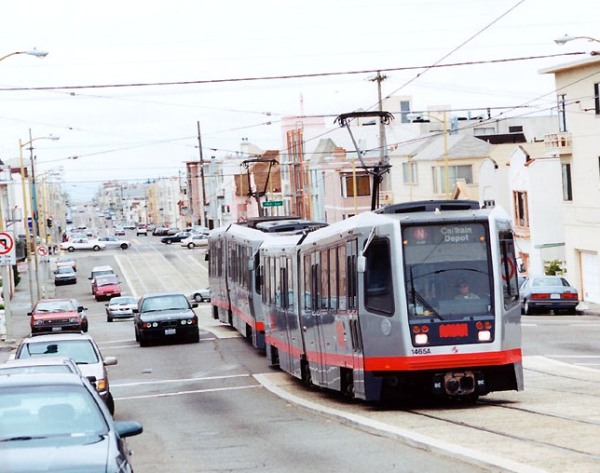
San Francisco's N-Judah light rail transit (LRT) line provides a model of how 2-track LRT can be fitted into a narrow arterial. Photo: Eric Haas.

San Francisco’s N-Judah light rail transit (LRT) line provides a model of how 2-track LRT can be fitted into a narrow arterial. Photo: Eric Haas.

How can dedicated lanes for a 2-track light rail transit (LRT) line be inserted into a relatively narrow 75 to 80-ft-wide arterial street or roadway, while maintaining basic 2-lane traffic flow capacity in each direction? Plus facilities for pedestrians and bicycles?

LRN technical consultant and Railway Age online writer Lyndon Henry describes how in a proposal prepared for the 13th National Light Rail & Streetcar Conference co-sponsored by the Transportation Research Board and American Public Transportation Association, to be held next week in Minneapolis, Minnesota. Titled A Proposed Design Alternative for Inserting Dedicated Light Rail Transit Lanes and Other Facilities in a Constrained Arterial Roadway, the proposal will be presented in the Complete Streets session on Monday, Nov. 16th. Here’s an abstract of the report:

Plans for inserting new light rail transit (LRT) tracks and other facilities directly into existing streets and arterial roadway s often encounter the problem of constrained right-of-way. This can present a serious challenge, especially when maintenance of basic traffic lane capacity is desired together with dedicated transit lanes. This paper suggests, as an example, a design solution that may be applicable or adaptable to similarly challenging situations. In a right-of-way width limited to 80 feet/24.2 m , inserting dedicated lanes for LRT while maintaining four traffic lanes plus adequate pedestrian and bicycle facilities was a significant design challenge. The proposed solution utilizes the adaptation of a very similar example of San Francisco’s Muni Metro (LRT) N-Line running in Judah Street. It also relies on Best Practices from several existing LRT systems and other sources such as the National Association of City Transportation Officials.
Hopefully the design concept described in this paper may be useful to the intended audience in suggesting a possible approach to solving similar problems involving the installation of LRT alignments in constrained arterial roads. It is expected to have applicability, potential adaptability, and transferability for a broad range of North American communities confronting similar design challenges.

Both a copy of the paper and the PPT presentation can be downloaded here (as PDFs):

Proposed Design (paper):
LH_Design-alternative-dedicated-LRT_doc-public

Proposed Design (PPT):
LH_Design-alt-LRT-in-arterial_ppt-public

Austin: Support for “Plan B” urban rail in Guadalupe-Lamar corridor advances

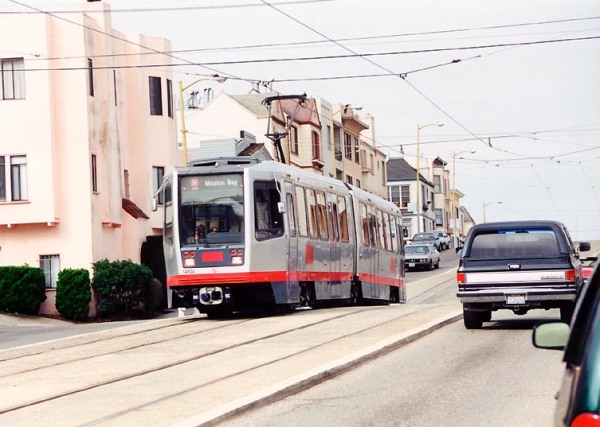
Proposed design for dedicated light rail alignments, retaining 4 lanes of traffic, could resemble San Francisco's Muni Metro N-Judah light rail alignment in Judah St., seen here near 16th Ave. Photo: (copyright) Eric Haas.

Proposed design for dedicated light rail alignment in Austin’s Guadalupe-Lamar corridor, retaining 4 lanes of traffic, could resemble San Francisco’s Muni Metro N-Judah light rail alignment in Judah St., seen here near 16th Ave. Photo: (copyright) Eric Haas.

Austin, Texas — Community support is mounting to apply millions of dollars in available municipal funds to resume the decades-old planning for light rail transit (LRT) in the city’s Guadalupe-Lamar corridor, described in a recent Austin Rail Now (ARN) posting as Austin’s “most central north-south corridor, with by far the heaviest travel and congestion.”

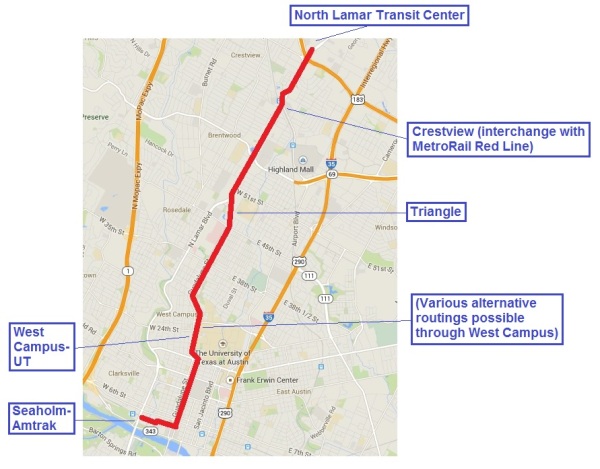
Several possible route plans for LRT in the corridor have been suggested. As this blog reported in November, one of these, proposed by ARN, would stretch 6.8 miles, with a short link to the city’s developing Seaholm-Amtrak station site, for a capital cost of $586 million.(See map below.)


Annotated map of proposed Guadalupe-Lamar LRT line shows various major activity and population points served, as well as connection to Seaholm-Amtrak site. Map: Austin Rail Now.

Annotated map of proposed Guadalupe-Lamar LRT line shows various major activity and population points served, as well as connection to Seaholm-Amtrak site. Map: Austin Rail Now.


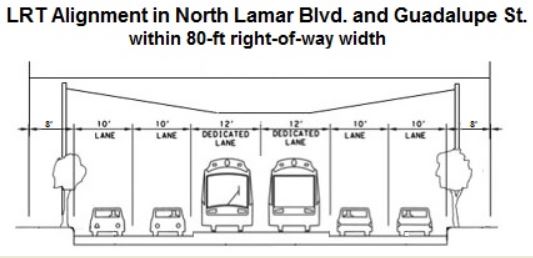
In a December posting, ARN presented a proposed design to install dedicated LRT tracks in North Lamar Blvd. and Guadalupe St., while retaining four lanes of traffic as well as sidewalks for pedestrians and bicycles. Modeled after San Francisco’s Muni Metro N-Judah LRT route in Judah St., the design shows how an effective LRT line could work within what is mostly an 80-foot-wide right-of-way. (See photo at top of this post and graphic of cross section below.)


Cross-section of proposed LRT line, showing dedicated track alignment, 4 lanes of traffic, clearances, and facilities for pedestrians and bicycles. Graphic: ARN.

Cross-section of proposed LRT line, showing dedicated track alignment, 4 lanes of traffic, clearances, and facilities for pedestrians and bicycles. Graphic: ARN.


Widespread community support for such an urban rail line in this high-traffic, dense central corridor is evident. The crucial task is to gain official cooperation. But, warns ARN in a posting earlier this month, despite this community backing, a long history of previous study of the corridor, and suggestions for route and design options, key local officials “seem to have been struck blind and deaf, oblivious to the obvious feasibility of LRT in the city’s most central and heavily used local corridor.”

On the other hand, a recent major overhaul in Austin’s local government, reorganizing how councilmembers are elected and installing entirely new representatives, may open the possibility that things will change. As ARN‘s article asks,

Will a new mayor and a new district-based 10-1 City Council provide an opportunity to scrap this modus operandi of failure and disaster, bring the community into authentic involvement in crucial decisions, and move forward with the first phase of LRT as a starter line in Guadalupe-Lamar?

This is a developing saga worth following… ■

Austin: As urban rail vote fails, campaign for Plan B light rail rises

"Plan B" is a 6.8-mile light rail starter line route for Austin's most central inner-city local corridor. It was originally proposed as a more feasible alternative to the official "urban rail" plan, defeated on Nov. 4th. Map graphic: Austin Rail Now.

“Plan B” is a 6.8-mile light rail starter line route for Austin’s most central inner-city local corridor. It was originally proposed as a more feasible alternative to the official “urban rail” plan, defeated on Nov. 4th. Map graphic: Austin Rail Now.

Austin, Texas — In a somewhat astonishing victory, on November 4th the city’s most dedicated, experienced, and knowledgeable rail transit advocates — including leaders of the Light Rail Now Project — helped defeat an officially sponsored rail transit plan that they said would waste resources on a very weak route and actually set back rail transit development in the community. See: Austin: With flawed “urban rail” plan now on ballot, debate heats up.

Produced by a consortium of several public agencies called Project Connect, the official plan — designated “urban rail” but in fact deploying light rail transit (LRT) technology — proposed a 9.5-mile route connecting the declining Highland Mall shopping center on the city’s north side (also a site being developed as a new Austin Community College campus) to the East Riverside corridor in the southeast. While the proposal was projected to have an investment cost of $1.4 billion in 2020, Austin’s City Council placed a $600 million General Obligation bond measure on the ballot as the local share, in hopes that the remainder would be covered by federal grants and other undisclosed sources.

It was that bond measure that was defeated, by a 14-point margin, 57%-43% — a stunning triumph for opponents, outspent 2-to-1 by a powerful coalition of the core of Austin’s business and predominantly Democratic political leadership, who also managed to enlist the support of major environmental, liberal, New Urbanist, and other “progressive” leaders. But a coalition of transit advocates and many other community and neighborhood activists otherwise inclined to support rail transit vehemently opposed the plan, objecting to what many perceived as a scheme that ignored crucial mobility needs in deference to real estate development interests. Many community members also felt excluded from what was depicted as a “fraudulent” process that had engendered the proposal. See: The fraudulent “study” behind the misguided Highland-Riverside urban rail plan.

For analyses of the campaign and defeat of the Highland-Riverside rail plan, see:

Austin: Flawed urban rail plan defeated — Campaign for Guadalupe-Lamar light rail moves ahead

Lessons of the Austin rail bond defeat

Austin urban rail plan: Behind voters’ rejection

Austin urban rail vote fails, alternative light rail plan proposed


With Austin's most powerful business leadership, mass media, and Democratic Party-dominated political leadership arrayed against them, grassroots rail advocates, community activists, and neighborhood groups opposing the official "urban rail" proposition seemed to face overwhelming odds. Graphic via TheKnowNothingNerd.com.

With Austin’s most powerful business leadership, mass media, and Democratic Party-dominated political leadership arrayed against them, grassroots rail advocates, community activists, and neighborhood groups opposing the official “urban rail” proposition seemed to face overwhelming odds. Thus defeat of the official “urban rail” plan on Nov. 4th was an amazing upset. Graphic via TheKnowNothingNerd.com.


While the defeat of the City’s official plan might be seen as one step back, it could well lead to several steps forward in the form of a new “Plan B” LRT starter line in the central city’s heaviest-travel local corridor, potentially making far more sense to voters and attracting much broader support. This route, original proposed in the 1970s and intensively studied since the 1980s (and very narrowly defeated by less than 1% of voters in a 2000 regional referendum), follows the major arterials North Lamar and Guadalupe Street, serving increasing residential density and commercial activity in the corridor including the West Campus area adjacent to the University of Texas campus, with the third-highest residential density in Texas.

Various alternatives for a light rail starter line to serve this corridor are possible; one prominent example is a plan recently proposed by Austin Rail Now (ARN, a coalition of rail supporters including the Light Rail Now Project). As illustrated by the annotated map at the top of this post, this proposal envisions a 6.8-mile line, running from the North Lamar Transit Center (at U.S. 183) to the city’s Core Area (comprising the UT campus, Capitol Complex, and Central Business District). Along the way, it would provide a connection to the MetroRail diesel-multiple-unit-operated regional rail passenger service at the Crestview station (also a major development site), and important the Triangle multi-use development further south.

This plan also includes a branch stretching west to a new urban development site located at the former Seaholm electric power plant and current Amtrak intercity train station (at the western edge of the CBD). See: A “Plan B” proposal for a Guadalupe-Lamar alternative urban rail starter line.

With 17 stations and a fleet of 30 LRT railcars, ARN’s Plan B is designed to carry daily ridership of as many as 30,000 to 40,000 rider-trips — a figure derived from federally funded studies of the 2000 proposal, and roughly two to three times as much ridership as was likely for the now-defunct Highland-Riverside scheme. Yet, at a projected $586 million, and with no major civil works along the Guadalupe-Lamar corridor, it would have roughly half the investment cost, and an affordability likely to be more appealing to voters.

Furthermore, a cost-effective and financially doable starter line located in Austin’s centralmost and most heavily traveled inner-city local corridor could plausibly serve as the central axis or trunk of a far larger citywide LRT system, with lines branching into many other neighborhoods and outlying communities.


LRT in Austin's North Lamar and Guadalupe corridor could resemble Portland's Yellow Line on Interstate Avenue, shown here. Photo: Peter Ehrlich.

LRT in Austin’s North Lamar and Guadalupe corridor could resemble Portland’s Yellow Line on Interstate Avenue, shown here. Photo: Peter Ehrlich.


Supporters hope that this illustration of a Plan B LRT concept for Guadalupe-Lamar will provide a spark to re-kindle an official rail planning process that truly makes sense. Key to any plan for expansion of transit in Austin is acceptance of the need for re-allocating some street space — and traffic lanes — to dedicated transit use, and this policy is included in the proposal.

Most important, unlike the defeated urban rail proposal, a Plan B LRT on Guadalupe-Lamar seems to be an initiative that comes from the community itself. That’s an excellent ingredient for success. ■

Austin: With flawed “urban rail” plan now on ballot, debate heats up

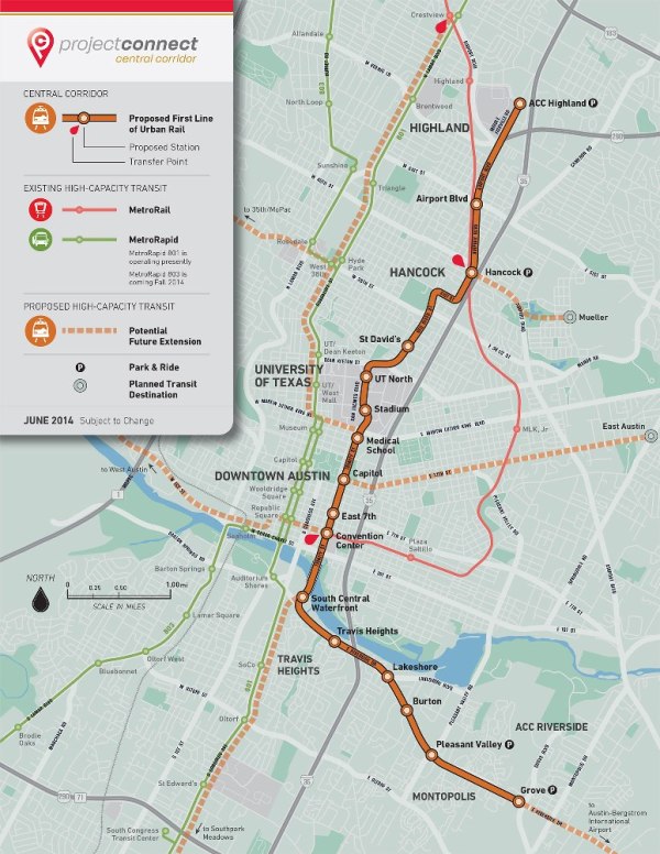
Project Connect's 9.5-mile, $1.4 billion urban rail (light rail transit) proposal is opposed by the staunchest and most knowledgeable rail transit proponents in Austin. Map: Project Connect.

Project Connect’s 9.5-mile, $1.4 billion urban rail (light rail transit) proposal is opposed by the staunchest and most knowledgeable rail transit proponents in Austin. Map: Project Connect.

Austin, Texas — For months, this city’s staunchest and most knowledgeable rail transit advocates, including the Light Rail Now Project team, have been leading the criticism of an “urban rail” (light rail transit) plan being proposed by Project Connect, a consortium of several public entities, including the City of Austin, the Capital Metropolitan Transportation Authority (Capital Metro), and the Capital Area Metropolitan Planning Organization (CAMPO). A central focus of most of this criticism has been the fact that the proposed route fails to serve the city’s premier central corridor, identified as Guadalupe-Lamar because it follows two major arterial roadways by those names.

Project Connect’s route, a meandering 9.5-mile alignment now priced at roughly $1.4 billion (2020 dollars), instead seems to try to create a new corridor from a southeastern area known as the East Riverside corridor, across the Colorado River and north through the east side of the CBD, through the East Campus of the University of Texas, and through a somewhat convoluted connection to a declining shopping mall site, known as Highland Mall, now being transformed into a new Highland campus for Austin Community College (ACC). However, at a staggeringly high cost, the proposed line fails to solve critical mobility needs, misses the major local travel corridor of the central city (Guadalupe-Lamar), and misses the high-density West Campus neighborhood area.

Rail proponents also warn that, by “soaking up all the oxygen” (available financial resources), the project would seriously constrain further rail development and extensions throughout the city. Furthermore, the dubious urban rail plan (driven more by desires of real estate developers than by mobility needs) also seems linked to a plan to entrench the MetroRapid bus operation (portrayed as “bus rapid transit”) in the Guadalupe-Lamar corridor, where it would likely become a barrier to urban rail development there.

On June 26th, the Austin City Council designated the Project Connect plan as the city’s Locally Preferred Alternative (LPA), and on August 7th the Council authorized a ballot measure that asks voters to approve $600 million in general obligation bonds to pay for a local portion of the proposed urban rail project. The ballot language stipulates that bonds could only be issued if the City finds an additional $400 million in funding for an array of roadway projects, including roadwork on Interstate 35 running through the city.

The Austin Rail Now website (a project partly sponsored by Texas Association for Public Transportation and the Light Rail Now Project) has been a significant resource of information and analysis on Austin’s recent urban rail planning, including alternative plans as well as drawbacks of the official plan developed and recommended by Project Connect. Most of this material represents potentially useful guidance for other communities similarly involved in rail system planning. Listed below are just a few of the key major articles posted on the site that provide a better overview and insight into the forest of issues involved. ■

Project Connect planning problems

Project Connect’s “corridor” study — without corridors!

Surprise! Mayor and Project Connect select same routes they wanted in the first place

Questions for Project Connect

Memo to CCAG: “Pause” study or include “Lamar” sector

Project Connect Needs an Overhaul

What’s with Project Connect’s “2.9 million daily ridership” projection?

Will Project Connect continue to gag the public?

Science seems missing from Project Connect’s “scientific” transit planning

Project Connect’s urban rail forecasting methodology — Inflating ridership with “fudge factor”?

Reality Check: How plausible are Project Connect’s time/speed claims for Highland-Riverside urban rail plan?

Problems of Project Connect’s urban rail proposal

Dobbs: “Why are we squandering our best asset?”

Project Connect’s wasteful plan — Ultra-pricey urban rail “decoration” in the wrong route

Project Connect’s Austin urban rail would be 3rd-most-pricey LRT starter line in U.S. history

Project Connect’s urban rail plan “costs way too much to do too little”

Project Connect’s $500 million plan for bus infrastructure — The Elephant in the Road on Guadalupe-Lamar that could block urban rail

Project Connect’s urban rail plan is “worse than nothing”

Why Project Connect’s “Highland” urban rail would do nothing for I-35 congestion

Why Project Connect’s urban rail plan would remove just 1,800 cars a day — not 10,000

Project Connect’s gold-plated Austin urban rail plan shows planning process way off course

Three “incontrovertible facts” about urban rail proposals in Austin

Political issues of Project Connect plan

City Council to Central Austin: Drop Dead

City Council to Austin community: Shut Up

Baker: Connecting some dots on Austin’s urban rail planning

Official urban rail plan bulldozed to ballot — in bulging bundle

Guadalupe-Lamar alternative

An alternative Urban Rail plan

Give priority to “Missing Link”

Demographic maps show Lamar-Guadalupe trumps Mueller route for Urban Rail

Another alternative urban rail plan for Guadalupe-Lamar corridor

Guadalupe-Lamar urban rail line would serve 31% of all Austin jobs

How urban rail can be installed in the Guadalupe-Lamar corridor

Why the MetroRapid bus project currently is NOT an obstacle to urban rail in Guadalupe-Lamar

Contradicting local official claims, FTA says it “would consider request” for urban rail on North Lamar

West Campus is where the students are!

Austin’s 2000 light rail plan — Key documents detail costs, ridership of Lamar-Guadalupe-SoCo route

Cases where voters okayed rail transit after first rejecting

Rail transit ballot measures are critical events. But if one is rejected, is it a "catastrophic" for the community? Graphic: RochesterSubway.com.

Rail transit ballot measures are critical events. But if one is rejected, is it a “catastrophic” setback for the community? Graphic: RochesterSubway.com.

Voter rejection of a rail transit project is almost always unfortunate.

But is it catastrophic? Does it signal that the majority in a community will persistently and permanently reject any rail project, or does it represent a more temporary setback, with remaining hope that a better plan, a better presentation to voters, at a better time, could have a chance to win approval?

This issue often arises not only in communities where a rail transit project has unified support from transit advocates, but even in cases where an official plan has faced strong opposition from rail transit supporters. In an effort to mobilize support, proponents of the given project may argue that it may be the community’s “only chance for rail”, that, no matter its deficiencies, a given plan cannot be allowed to fail, because it would be a “disaster”, setting back rail development for decades, perhaps forever.

To evaluate the validity of this argument, and assess the actual delay between the failure of rail ballot measures and the ultimate passage of support for a subsequent rail transit ballot initiative, the LRN Project team examined available cases since 2000 where an initial rejection of rail was followed by a successful later vote. LRN’s approach has examined this issue strictly from the standpoint of attracting voter support — in other words, if the issue of rail transit is re-voted, how long does it take to win approval?

It should be noted that this study has examined the sequence of events only in cities where, after the failure of an initial measure, a new measure for rail transit (often with a somewhat different plan) was offered to voters. In other cases, poorly prepared or presented rail plans were rejected by voters, but rail planning was subsequently dropped (e.g., Spokane, Columbus) or has proceeded without needing a public vote (e.g., San Antonio).

Thus this study has sought to address the question: If rail has previously been rejected by voters, but a new rail measure is subsequently presented for a vote, how long does it take to achieve successful voter approval for rail?

Since 2000, there have been six cases where such re-votes have occurred:

Austin — A plan for a light rail transit (LRT) system was very narrowly defeated in 2000; rail transit was subsequently repackaged as a light railway using diesel-multiple-unit (DMU) rolling stock, and passed in 2004 (now branded as MetroRail). Delay between votes: 4 years.

Kansas City — An officially sponsored LRT plan was defeated in 2001; a different LRT plan initiated by a citizens’ referendum was subsequently approved in 2006. (However, the successful vote was annulled by the city council; implementation of an officially sponsored streetcar project is now underway without a public vote.) Delay between votes: 5 years.

Cincinnati — An LRT plan was rejected in 2002. Rail transit was subsequently repackaged as a streetcar plan that was forced to a public vote, and ultimately was approved in 2009. (A re-vote, forced by opponents’ referendum, was held in 2012, and the streetcar project again passed.) Delay between votes: 7 years.

Tucson — An LRT plan was rejected in 2002; rail transit was subsequently repackaged as a streetcar plan, then submitted for a public vote and approved in 2006. (The new system, branded as Sun Link, is due to open later this year.) Delay between votes: 4 years.

Seattle — A multi-modal transportation proposal, Roads and Transit, including LRT expansion, was defeated in 2007 (with opposition from environmental organizations and other traditional pro-transit groups, dissatisfied with the plan’s heavy highway element). A new package, Sound Transit 2, was prepared, with much heavier transit emphasis, and presented and approved by voters in 2008. Delay between votes: 1 year.

St. Louis — Proposition M, including funding for the region’s MetroLink LRT system, was defeated by voters in 2008. A new package, Prop. A, aided by an improved campaign, and including funding to improve and expand LRT, was subsequently approved in 2010. Delay between votes: 2 years.

From these experiences, it’s plausible to conclude the recent re-votes on rail transit have taken from one to seven years to succeed. This would not seem to suggest that initial loss of a vote results in a “catastrophic” delay of “decades” before a rail transit project can muster approval.

On the contrary, the average delay, on the basis of these cases, is 3.8 years. However, the data seems to suggest a pattern, whereby the delay before a successful rail transit re-vote is less in cities already operating some form of rail transit (Seattle, St. Louis), in contrast to cities where rail would be a totally new addition to the transit mix (Austin, Tucson, Kansas City, Cincinnati). This differential in average delay is illustrated graphically in the chart below:

Left bar: Average years of delay in cities already operating rail transit. Right bar: Average delay in cities with no current rail transit.

Left bar: Average years of delay in cities already operating rail transit. Right bar: Average delay in cities with no current rail transit.

Other than to infer that the loss of a vote does not inevitably represent a “catastrophic” setback for rail transit in a given city, this study with its very small data set does not offer a basis for strong conclusions. However, there is opportunity for plausible speculation:

• Conditions for a more speedy re-vote and approval of a rail transit ballot measure may be more propitious in communities that already have experience with successful rail transit systems.

• The process of re-submitting a rail transit measure to a vote may depend not so much on public attitudes but on the determination of sponsoring officials, their responsiveness to public input, and their willingness to re-craft specific project details to more closely conform to public needs and desires.

How Portland’s light rail trains and buses share a transit mall

LRT train on Portland's 5th Ave. transit mall swings to the curbside station to pick up waiting passengers. Photo: L. Henry.

LRT train on Portland’s 5th Ave. transit mall swings to the curbside station to pick up waiting passengers. Photo: L. Henry.

How can both buses and light rail transit (LRT) trains share the same transit-priority paveway or street? There are numerous examples that answer this, but certainly one of the best is in Portland, Oregon — the 5th and 6th Avenue transit malls.
Recently, the Austin Rail Now (ARN) blog posted an article focusing on Portland’s transit malls, and because of the more general usefulness of this information for many more communities, we’re re-posting it here with the kind permission of ARN.
The opening context for the article is the urban rail planning project currently under way by the City of Austin, Capital Metro (the transit authority), and a transit planning consortium called Project Connect. Transit priority lanes are now being installed on two major downtown north-south streets, and it’s been expected that urban rail trains would share these with buses, including the MetroRapid premium-bus services now being implemented in several major city corridors. However, some transit advocates are noting that these lanes may have insufficient capacity to handle all the bus routes plus MetroRapid, much less adding LRT into the mix.
Portland’s experience thus provides an illustration of how LRT trains and buses can share a priority alignment in a way that works well.

Capital Metro and the City of Austin have a project under way to designate “Transit Priority Lanes” on Guadalupe and Lavaca Streets downtown between Cesar Chavez St. and MLK Jr. Blvd. It’s mainly to expedite operation of the planned new MetroRapid bus services (Routes 801 and 803), but virtually all bus routes running through downtown will also be shifted to these lanes, located on the far-righthand side of traffic on each street (i.e., the righthand curbside lanes).

According to a 2011 study funded by the City of Austin, the Official (City + Project Connect) Urban Rail route is also envisioned to use these lanes downtown. Alternatives to the Official plan have also assumed that these routes would be available for alternative urban rail lines serving the Guadalupe-Lamar corridor.

However, there are legitimate questions as to whether these two lanes could simultaneously and effectively accommodate the two MetroRapid bus routes (10-minute headways each) plus all other Capital Metro routes (various headways) as well as urban rail (10-minute headway), all running in both directions.

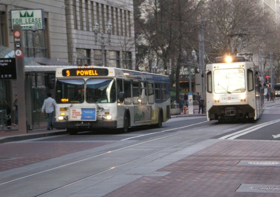
Experience with both light rail transit (LRT) trains and buses sharing the same running way is rare in the USA, but one of the best examples can be seen in Portland, Oregon. For years, 5th and 6th Avenues through the downtown have been used by multiple bus routes as a transit mall, with a single lane provided for general motor vehicle access. In September 2009 LRT was added with the opening of the new Green Line; see: Portland: New Green Line Light Rail Extension Opens.

The integration of LRT with bus service in the 5th and 6th Avenue transit malls has worked well. Here’s a brief photo-summary illustrating some of the configurational and operational details.

• Buses and LRT trains share transitway

This illustrates how both bus services and LRT trains share the mall. Tracks, embedded in the pavement, weave from curbside to the second lane over. A third lane is kept open for mixed motor vehicle traffic.

Portland 5th Ave. transit mall. Photo: Dave Dobbs.

Portland 5th Ave. transit mall. Photo: Dave Dobbs.

• LRT routes cross

This photo shows how the Green and Yellow LRT lines on the 5th Ave. transit mall cross the Red and Blue LRT lines running on 5th St. You’re looking north on 5th Ave., and just across the tracks in the foreground, the LRT tracks on 5th Ave. weave from the middle of the street over to the curbside, where a station-stop is located. This allows LRT trains to access stations but otherwise pass buses stopped at bus stops on the same street.

Portland 5th Ave. transit mall. Photo: L. Henry.

Portland 5th Ave. transit mall. Photo: L. Henry.

• LRT train leaving station

Here an LRT train has just left the curbside station, following the tracks into the middle lane of the street. This track configuration allows the train to pass a bus boarding passengers at a stop.

Portland 5th Ave. transit mall. Photo: Dave Dobbs.

Portland 5th Ave. transit mall. Photo: Dave Dobbs.

• LRT train passing bus

Another train moves to the street center lane and passes the bus stop. Meanwhile, other buses queue up at the street behind.

Portland 5th Ave. transit mall. Photo: Dave Dobbs.

Portland 5th Ave. transit mall. Photo: Dave Dobbs.

• Bus bunching

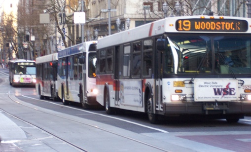
Buses are prone to “bus bunching” (queuing) in high-volume situations because of their smaller capacity, slower operation, slower passenger boarding/deboarding, difficulty adhering to schedule, etc. However, notice how they’re channeled to queue up in a lane off the LRT track.

Portland 5th Ave. transit mall. Photo: L. Henry.

Portland 5th Ave. transit mall. Photo: L. Henry.

Can and will Austin and Project Connect planners learn anything about how to create workable Transit Priority Lanes from examples like this? Time will tell…